Comparing Two Early iPhone GPS Navigation Apps
One of my favorite gadgets of the last four or five years is the car navigation GPS. Enter an address or pick a point-of-interest from a database, press the Go button, and it not only provides turn-by-turn directions in real time, it speaks the instructions out loud so you can focus on driving. I’ve reviewed numerous models from GPS manufacturers Garmin, Magellan, and TomTom, but my first experience with GPS navigation came from a cell phone in a rental car during a Mac user group tour in the Southwest.
When the iPhone 3G first appeared with a GPS chip in 2008, I was ecstatic, thinking that would mean iPhone users could avoid buying yet another gadget. But as much as the Maps app is useful, I found it devilishly difficult to use while driving, and it wasn’t until Apple announced iPhone OS 3.0 that a turn-by-turn GPS app became possible. I have yet to hear why that should have been true, but it was.
Although we’ve seen additional apps from TomTom and Navigon (and probably others) appear since I started this review, the first two GPS navigation apps for the iPhone were AT&T Navigator and G-Map from XRoad, and those are where I’ll start. I hope to look at the others soon.
AT&T Navigator is a free app from AT&T, but requires a $9.99 monthly service charge. I hate that. G-Map costs $34.99 and consumes 846 MB of space, but requires no monthly fee. During a multi-day trip from Ithaca, NY to Boston, MA, I tested both, sometimes simultaneously with a Garmin nuvi 255W, which I reviewed a year ago (see “Garmin nuvi 255W Focuses on Navigation,” 2008-08-07).
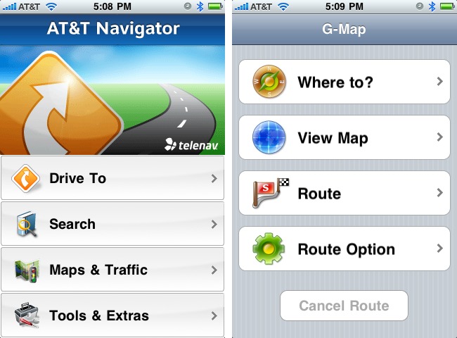
Online vs. Offline — The first major difference between AT&T Navigator and G-Map – and all other standalone GPS devices, for that matter – is that AT&T Navigator stores hardly any information on your iPhone. Instead, it requires constant communication with AT&T’s servers to download route information.
Needless to say, this can be a significant limitation if you drive in areas that lack cellular coverage, as is true of parts of upstate New York. There were a few times that AT&T Navigator was unable to connect, but luckily, none of those times coincided with a turn. During later testing in Ithaca, where cell service is often spotty, there were times I couldn’t even get AT&T Navigator to load, due to the lack of service.
I’m surprised that the AT&T Navigator app doesn’t download and cache the entire route upon starting, so that it could rely at least on cached instructions if connectivity was lost, throwing up its hands only if you were to deviate from the cached route.
G-Map didn’t suffer from the same limitation, of course, but the tradeoff is that it requires 846 MB of space on the iPhone… for just the East Coast of the United States. That’s a large percentage of the iPhone’s space to allot to a single app, although you could of course load and unload it as necessary. If you want additional maps from G-Map, you must buy separate apps.
In contrast, the Garmin nuvi 255W contains maps for all of North America or Europe (depending on model), and a card slot lets you add even more maps. Score one for the standalone GPS.
Finding Destinations — Aside from actual navigating, the primary interaction you have with any GPS is locating your destinations. GPSes offer several basic ways of finding locations, of which entering addresses and looking up points-of-interest are the most common.
Here’s where I hoped the iPhone apps would prove significantly easier to use than the Garmin nuvi 255W, because, although it has a touch screen and a large database of points-of-interest, its interface is clumsy, and it doesn’t integrate with your normal contact database.
Although I could swear this wasn’t true of the initial release of AT&T Navigator, the app now offers direct integration with your contacts list, which is huge. Most of the time, when you’re going to someone’s house, you already have their address in Contacts, and if you don’t, it’s easy to enter, either via the iPhone itself or in Address Book on the Mac.
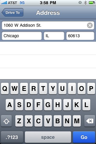
If you do need to type an address into AT&T Navigator, it provides a screen with four fields – house number and street, city, state, and ZIP – and a keyboard for entering information. It’s easy to move from field to field, and the app even guesses at likely results as you type. You don’t even have to fill in all the fields: city and state or ZIP is sufficient to go to a town.
There is an alternative – you can call an AT&T voice response system that will attempt (poorly) to do speech recognition and walk you through finding your destination. I’m sure there are people who like using these systems, but I prefer ingesting lumps of wasabi when I’m feeling masochistic.
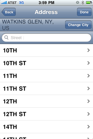
Oddly, G-Map has no integration with Contacts, which is a shame, given that its awkward interface makes the Garmin nuvi look polished. Instead of the fields in AT&T Navigator, G-Map makes you enter the street name and the house number on successive screens, and if you need to change the city or state from the previous search, doing so requires entering data on two more screens. Since all the screens look pretty much the same, you have to read carefully to figure out which screen you’re on at any given time. Score one for AT&T Navigator.
AT&T Navigator also won out when it came time to find businesses and other points-of-interest. Since G-Map must carry its point-of-interest database along with it, it isn’t nearly as comprehensive as AT&T’s, which can live on AT&T’s servers. Some categories I searched – like car rentals and hardware stores – were completely barren for Ithaca in G-Map, but had numerous entries in AT&T Navigator. In other categories, such as gas stations, both apps performed acceptably.
Plus, AT&T Navigator showed ratings for at least some businesses, which is a help when you’re on a trip and trying to decide between restaurants. Unfortunately, you cannot rate business from within the app itself, which would be helpful; AT&T claims in its FAQ that you can do so from the Tools/Extra menu, but that’s apparently untrue of the iPhone app.
G-Map did have one significant advantage over AT&T Navigator when searching points-of-interest. Since it didn’t have to query remote servers over what could be a slow or nonexistent cellular connection, results were instantaneous. Many times I found myself annoyed at how long it took for AT&T Navigator to retrieve the results of my search.
Time Delay Navigation — Here’s the real crux of the matter – would I rely on these apps for directions in an unfamiliar city? The answer is yes, but not without some hesitation. Here’s why.
The iPhone’s GPS capabilities are certainly the stuff of science fiction when viewed from the perspective of what was possible 10 or 15 years ago. But compared to a modern-day car navigation GPS unit, the iPhone can’t quite compete. To be specific, it’s not as accurate as the Garmin nuvi 255W I was using as my control, and as a result, the GPS apps are more likely to get your position slightly off and take longer to notice if you make a turn that deviates from the current route.
Although it varied, my experience was that G-Map recovered from an unexpected turn more quickly than AT&T Navigator, often within 5 seconds, undoubtedly thanks to its local database.
AT&T Navigator had to notice the incorrect turn, transmit the new location to AT&T’s servers, receive the new route back, and display it. That could take up to 30 seconds, which I found highly troubling in some situations.
If you’re on a slow-moving freeway with few exits, 30 seconds may not matter, but if you’re on a busy city street, you could miss an important turn or simply be more at risk of an accident. My experience with the standalone devices is that they usually recover within a few seconds, and in any event quickly enough that there’s no more stress added to the situation.
G-Map wins on two counts here, in fact. Its route recalculation is faster, and because its maps contain more details – specifically, more street names – than AT&T Navigator’s maps, you can glance at the screen and see more of what’s around you.
Routes — Some trips aren’t simple, if you need to make several stops along the way, and in other situations, you may need to consult a route list to ensure the directions make sense.
AT&T Navigator offers useful route summaries, both in text and in map form. You can also see a traffic summary that supposedly shows traffic delays, and you can ask it to avoid particular segments of the route. It’s a clean interface, and easy to use under pressure, which is often the situation when you’re consulting the route list.
In contrast, G-Map can show you a list of intersections along with a close-up of the turn, but the list lacks distances and turn directions, so it’s not useful on its own. It can also preview a route graphically, showing how you’d drive. You can increase the speed so it’s not as slow as actually driving would be, but it’s still tedious to watch.
G-Map also enables you to create multi-point routes. I find that I generally just go from one point to the next, reprogramming the GPS once I’m ready to head out to the next destination, but I’m sure there are instances where a predefined route would be useful. AT&T Navigator has no such feature.
Speak Up — I appreciate the visual maps provided by these apps, and both are totally usable (G-Map’s have more detail), but the real utility of a car navigation GPS is its capability to speak directions to you, so you can keep your eyes on the road.
AT&T Navigator works as expected, reading both directions and street names (this is optional, though the default). Unfortunately, and this may be because of needing to download data from AT&T’s servers, the voice quality is poor. I had no trouble understanding the AT&T Navigator voice, but the difference was obvious once I switched to G-Map, which has a much clearer voice.
Alas, G-Map can read only directions audibly, leaving you to glance at the map if you’re uncertain which of two upcoming left turns it means. It does play a two-note tone every time you come to a turn (an audible interface element pioneered by Magellan), which helps.
AT&T Navigator won out in another way as well. If you want to listen to music or a podcast while driving, you can run the iPod app in the background, and AT&T Navigator will pause the music to speak some directions, then start playback again. The only downside is that AT&T Navigator is one of the chattiest GPS navigators I’ve ever used, so the constant pausing and playing was almost more annoying than it was worth. On one trip I shut it off entirely because I couldn’t stand the constant interruptions from the low-quality voice.
Weirdly, G-Map not only wouldn’t allow me to play music in the background – it just didn’t work – but the app’s voice directions also stopped working entirely if I plugged my car’s cassette adapter into the iPhone’s headphone jack. Since it was impossible to hear AT&T Navigator unless I ran it through the car stereo, this G-Map bug threw me for some time.
Neither app offers choices of voices, as do the standalone GPS devices, most notably TomTom’s units, which let you download custom voices and even record yourself. Both apps offer a basic female voice, which is fine. AT&T Navigator does offer the option of English or Spanish.
More Power, Scotty! One area in which neither iPhone app could excel was in power usage. Relying on the app to give you directions requires that it keep the GPS chip and the screen active at all times, which drops battery life to about 2 hours.
The battery-powered standalone GPS units I’ve tested aren’t notably better, but of course, if you let your iPhone run out of power, you’ve lost more than just your navigation help.
AT&T Navigator can dim or even black the screen, but that may not be safe, since you’re most likely to want to see the map when you’re in a confusing situation, and that’s the worst time to need to fiddle with the iPhone.
So if you’re going to use any iPhone GPS app, make sure to get yourself some sort of car charging device so you can be sure your iPhone will be fully juiced up at the end of the trip.
Various Nits — Along with the criticisms I’ve noted so far, they also suffer from a number of minor nits, some which may disappear in future versions, but others of which are artifacts of the iPhone platform.
- All standalone car GPS units come with mounts and power adapters. Neither iPhone app does, of course, which means that you need to acquire a mount and power adapter separately. I ended up getting the Arkon IPM129-ST Removable Air Vent Mount, which is a cheap (in every sense of the word) mount that attaches to an air vent; it works, but was hard to install and fit only on the side vent in our Honda Civic, which means the Griffin Technology PowerJolt SE power adapter cord barely reaches.
- Both apps present a splash screen that you must dismiss on every launch telling you not to interact with the app while driving (standalone GPSes do this too). I understand why the lawyers require such an interface abomination, but it’s still an abomination. Perhaps it could appear on a random sequence, but with fewer appearances as you used the app more and more.
- G-Map’s content – addresses, business names, and so on – is entirely uppercase, which makes parsing it visually difficult. AT&T Navigator uses mixed case, which is much easier to read.
- Neither app was very good at what is often the most confusing part of a new route – figuring out how to get started. That may be due to the lack of accuracy in the iPhone GPS chip, but if I’m in a driveway, I’d like to have an instruction to turn right or left out of the driveway.
- Once, when returning home from a location near Cazenovia, NY, G-Map simply couldn’t give me a route home. It displayed a dialog saying that the route calculation had failed, and then crashed. AT&T Navigator worked fine in that situation.
- On several occasions, G-Map failed to pick up my current location right away when starting a new route, which was annoying if I’d travelled some distance since I last used it. Other times it found its new location nearly instantly.
- Neither app worked in landscape mode, which all of the standalone GPS devices use. It wasn’t a huge problem, and might not work well with various iPhone mounts, but it would have been nice. AT&T Navigator’s iTunes page claims it has this feature in version 1.3i, but 1.2 seems to be the latest version available.
- Although AT&T Navigator can seemingly detect traffic problems and route around them, all this seemed to entail was hearing it say “Checking traffic” ad nauseam – I never saw it actually change its behavior.
- AT&T Navigator’s extreme chattiness was exacerbated by the fact that if it could come up with a different name for a street, it would, unlike G-Map and the Garmin nuvi 255W, which seemed to map better to how the streets were actually labeled in the real world.
- Although G-Map shows how far to your destination and how long it will take, it does so in such small type that it’s nearly impossible to read while driving. AT&T Navigator uses larger type and toggles back and forth between arrival time and distance to destination.
Still Looking — Overall, although both apps would clearly do the job in the end, neither gave me the confidence to drive in the Boston metropolitan area – I continually wimped out and retreated to the Garmin nuvi 255W, which has never let me down in a major way.
The skinflint in me can’t stomach recommending AT&T Navigator unless you’re really good about canceling the service when you won’t be needing it. At $9.99 per month, a year of use would make it more expensive even than the pricey TomTom ($99.99) and Navigon ($89.99) apps.
And while G-Map’s (introductory) $34.99 price is more appealing, its clumsy interface, rough edges, lack of integration with Contacts, and inability to read street names make it a less-than-ideal choice. Plus, if you regularly travel on both coasts and Canada, you’d need multiple apps that would cost the same as the TomTom app. G-Map does have apps that cover more limited areas – California, New York/New Jersey, Florida/Puerto Rico, Texas, Wisconsin/Illinois, Minnesota/Indiana, and Canada – and that cost only $19.99 and weigh in around 100 MB.
But in the end, I’m canceling the AT&T service – I just don’t need to pay $9.99 for a trip or two per month – and I’ll be using G-Map until it’s time to review the next iPhone GPS app.
I'm probably the 1000th person to tell you the 3G doesn't have a magnetometer, the 3GS does. You need it to know where North is (versus simply knowing your point location on the earth).
True GPS needs to know not just location, but also orientation.
I haven't tested to see if there's a difference in how these things work on the iPhone 3G - I was testing on a 3GS and will update the article to mention that.
Are you planning reviewing also other brands, for example Sygic, TomTom or Navigon?
Definitely - just have to get review codes from the companies.
I've been using Navigon for several months on my 3GS and have found it very reliable. Integration with my contacts list is a huge bonus. A recent update adds iPod control without interrupting navigation. I always listen to audiobooks commuting and traveling. Navigation volume can be adjusted. I gave up AT&T navigator due to the fee and no interface with Contacts. My TomTom GPS now lives in my glovebox unused. Thoughtout.biz PED3-Auto puts the iPhone in clear view on my dash.
My wife and I are currently using two LG Chocolate phones with Verizon. I'd love to get a couple of iPhones for us. One of the strongest forces keeping us with Verizon is the wonderful VZ Navigator. I just keep paying my $10 per month for this, even though I could cancel and start again, just to keep my list of favorite places we visit out of our home area. Sure hope iPhones get it together someday for GPS...
Hi Adam,
I've plumped for Sygic VERSION 7.71 -- mainly 'cos it offered good stored maps of both NZ & Australia for $NZ85 (US$ 60). The maps for other countries look to be affordable. So far I've been impressed with its reliability. Usability takes some getting used to -- especially the screens for entering destination addresses. I'll be interested to read about how it stacks up in your hands.
John