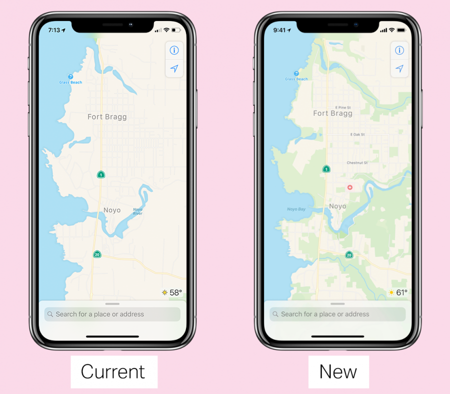
It’s no secret that Apple Maps is less than stellar, lagging behind Google Maps since its inception in 2012. Apple’s Eddy Cue revealed to TechCrunch that his team has spent the past four years overhauling Maps from the ground up. Soon you’ll see the results, starting with the California Bay Area in the next iOS 12 beta. The new Maps will be richer and more accurate, based on data collected both by Apple Maps vans and from users’ iPhones. As always, privacy is a top priority for Apple, and the company has made significant efforts to maintain the privacy of users. In addition to its initial coverage, TechCrunch has published answers to common questions about Apple’s forthcoming update.
I think this is excellent news. Maps has improved a lot (at least here in the States) so that nowadays I use it almost exclusively.
I sometimes miss Street View, but what I miss even more is good topographical information and trails. I want to be able to use Maps for my hiking (nothing crazy, just few-hour hikes in National and State Parks) just like I use it for my driving. Google has a nice Terrain overlay mode and I would really like to see something that come to Apple Maps.
One of the most severe problems with tech journalism is the bandwagon repetition of unresearched, unsupported, even flippant characterizations and assertions. Initial first-look impressions become tenets of unchanging dogma, from which many tech writers never seem able to recover. “Apple Maps has been a [six-year] joke” is only true, if we are talking about tech writers who write tech articles with the same depth of research, reliable analysis, and nuanced comparison of a standup comedian. Pundits were thrilled when Apple Maps stumbled out of the gate, and they declared it a failure with zeal. Most of them have maintained this position, without a second look, over the subsequent six years.
Apple’s announcement that they are working on improving the app has stimulated dozens of articles that I have seen so far, all of them parroting the same tropes that they created six years ago, as though nothing ever changed, nor can ever change. While I am used to poor quality tech journalism as the norm, TidBITS has usually produced much higher quality research, measured analysis, and meaningful commentary. Not today, apparently.
While Apple Maps has benignantly provided Josh with cost-free amusement for six years [substantially better than most comedians], it has been my primary navigation tool since the completion of the famous Tim Cook-announced reboot. Tim said Apple would fix the app, and Apple did. It has served me, very usefully, although humor-free, for at least five years. I compare Apple Maps to Google Maps at regular intervals, and while each makes mistakes from time to time, they both generally work well. I have preferred the Apple Maps interface and way of presenting the data and directions, every time I have done a comparison test. I’ve tried Waze, and don’t like its interface and the appearance of the maps. Google Maps does a few things especially well, and when I need those things, I switch to Google Maps. But for 90% of my uses, Apple Maps is my choice.
A particularly critical interface element is the timing of the instructions. With Google Maps, I frequently doubt whether the turn that I need is the next street, or the one after that. I often turn too early, and sometimes turn too late. These problems are less frequent with Apple Maps. The instruction timing for both maps is fine when I’m the passenger, and can look at the screen while listening to the instructions, and looking only for the next turn. But when I am driving by myself, my visual attention is on the other drivers, and the timing of the voice instructions is critical. Apple Maps works better for me. I have no doubt that for some other people, Google Maps has better timing.
Several years ago, Daring Fireball published an article saying that Apple Maps was the most popular navigation app on the iPhone. Other articles disagree. In any case, I think it is clear that many millions of iPhone users prefer Apple Maps for navigation, and don’t get the joke that Josh is referring to.
When Maps first came out, my brother noted an error near his house. The road he lives on, which dead-ends a few 100 yards from his house is shown continuing down into what is now a reservoir. Several roads branching off from that were also shown; these roads do not exist. He reported the error to Apple several times. the error is still present.
I suspect I am not alone in thinking that good technical journalism is concise, accurate, and, where appropriate, descriptive in framing developments within historical context. IMHO, Josh’s article accomplishes all of this very effectively and efficiently.
I think it is safe to assume that people who read TidBITS are at least passingly familiar with the history of iOS and Maps, and probably will appreciate that he did not blather on and on about something they already know.
I also think that TidBITS readers are knowledgeable enough about good journalistic practices to realize that because Apple did not provide specifics to TidBITS or to other media outlets than Tech Crunch so far, Josh wisely linked to the Tech Crunch article, which was truly the ethical thing to do.
Though I much prefer Apple Maps to Google Maps and agree with you on your reasons why, I do remember that when Maps was released, it was comparatively so deficient it became the butt of jokes in the trade press. I still read a lot of snide and snotty remarks about Maps in the trade press, most of whom seem to forget that Apple had to buy a mapping service and quickly rush out a very less than perfect version because Google released a version with turn-by-turn voice directions and announced they would not be updating Google Maps for iOS.
My thanks to Josh for another example of good journalism.
I was using Apple Maps in a fairly remote area of Western Australia a few weeks ago and was delighted with its detail, including satellite view (that is, where I had iPhone reception). I set a destination on my iPhone and was surprised to receive a tap from my Apple watch as a turn approached. This is a great feature as I don’t need to,look at the screen at a critical time.
I rarely use Google maps these days. I find it has become bloated and cumbersome to use, compared with a few years ago. But isn’t that the way of most software (MS Office, Windows, macOS…)?
Because I had family visiting yesterday, I asked Josh to post that piece before I’d had a chance to look at it. When I took my edit pass later, I changed—in the one-sentence summary of a one-paragraph link to another article—“Apple Maps has been a joke” to “If you thought Apple Maps has been a joke.” That was before seeing this discussion.
Even though I softened Josh’s criticism, I agree with it. I keep trying Apple Maps periodically, or because it’s easy to use with Siri, and I’m frequently disappointed. When driving in stressful situations in England recently, I had to use Apple Maps to get the map on the CarPlay screen, which engendered a great deal of swearing and eventually giving up and switching to Google Maps despite the lack of the on-screen directions. I would like to like Maps, because of Siri, but it lets me down way too frequently.
I also think it’s interesting that Apple has admitted that they have now spent four years rebuilding the underlying map from the ground up because tech companies almost never acknowledge that their products have issues until they have a replacement in hand. And Apple wouldn’t have spent what must have been hundreds of millions of dollars fixing it if Maps had met their own standards.
I’ll bet robo car development had a lot to do with the timing and scope of this.
My first comment was based on a different version of Josh’s comment. Adam notes the change in his comment. Adam’s experience is different from mine, perhaps since I use Apple Maps predominantly, and because I haven’t tried it in England. In any case, ignoring the six years of improvements that we have already seen in Apple Maps is misleading. Focusing a current review on the problems of the early versions similarly gives an inaccurate picture of the current product. I have no complaint if someone expresses an opinion that Google Maps is better, but Apple Maps is the preference of many millions, including at least four of the six current commenters in this thread, so calling it “a joke for six years” is wrong, and insulting to some of your readers.
User input for updates is probably an area where Waze has the best record. I live in rural area, and one of the major landmarks is the Volunteer Fire Department building. For years, Google Maps had it on the wrong corner of the wrong street. I submitted the correction several times, without result. Finally, they changed it. A couple of weeks later, it had been changed back to the incorrect location. I submitted the correction several more times, before the proper location became a stable feature in Google Maps.
At some point you have to switch to specialty apps for this. (You can’t really expect to have Maps do everything.) I have two on my iPhone, Komoot and Topo Maps+. I only use them occasionally, but they seem to have all of the trails in my area. A quick check of Google Maps shows none of the trails near home.
I’m surprised to hear that.
This is actually something I really like about Apple Maps. Whenever I spot an omission or error I usually send a short report. And in all cases I remember I usually got confirmation a few days later that the issue has been solved. This has worked for me in Japan, Europe, and the States.
I always got the impression actual people worked on these reports and speedily made changes to the databases. I very much liked that if felt like immediate improvements were possible. I always kind of wished Apple’s feedback pages were that efficient and gave the same speedy and effective responses.
Last Tuesday I was driving to a location I had never been to before in the north woods of Wisconsin. I have always preferred and used Waze, but when I got within 15 miles of my destination, I knew enough about where I was going that I could tell Waze wanted to send me in the totally wrong direction. So I switched to Apple Maps (1st time ever). I certainly did not know how to use the interface and it too did not get me to my destination, but it did get me close enough that I was able to find it on my own the last 2 miles.
Since then I have been using Apple Maps, more as a test to see if it’s “as good” as I thought Waze was, and to gain familiarity with the interface.
Bottom line is that Apple Maps works a whole lot better than I had expected. I had stayed away from even trying it because I bought into the fact that it was "a joke’. So in the future I will endeavor to take those comments with more grains of salt than in the past, and do more personal research. It appears that one man’s joke may be another’s salvation.
Couldn’t agree more. I love the fact that Waze allows user’s to submit updates and they get corrected quite quickly. They (Waze, Google, Yahoo, et. al.) had my home several blocks from where it actually is. It took a lot of correspondence and almost 3 years for Google to get it right. Waze took one submission and perhaps a couple months.
I also like Waze’s interactivity, with eh ability to report slowdowns, accident, road hazards etc. and to be warned about such things that others have reported in real time. It’s those features that will probably keep me using Waze, unless the new Apple Maps manages to supplant it.
I don’t use Apple Maps for navigation (I have a car system for that that works very well) but I can say that the satellite view of my neighborhood (west side of Las Vegas) hasn’t been updated in at least six years. It’s like looking into a time machine - empty space that is now full of homes and commercial buildings. The map itself shows most of the streets in the area, but is about six months out of date there also. It seems to me that one basic requirement for a map system is that the roads and views be up-to-date. Maybe if Apple pays more attention, this will improve.
Google bought Waze years ago. User participation feeds in a lot of information that they can’t get from Maps. If I remember correctly, it was not long after the “Facebook killer” social network they built became an obvious flop.
It was rumored at the time that Apple, and especially Facebook, were eyeballing the company. A Facebook acquisition especially spooked Google, which would give a them a big ad sales advantage, especially in hyper local advertising. They recently launched a big new initiative…they now serve ads that will run in the Waze ads that can be linked to digital billboards that will serve a super targeted messages:
https://www.adweek.com/sponsored/the-future-of-out-of-home-its-mobile/
Active participation ads a whole new dimension - someone stuck in traffic due to an accident while they’re driving to a retailer or restaurant can see an ad for a competitor. Keep in mind how especially powerful this will be for robo vehicles…cars and trucks.
I like Apple Maps but it’s undeniably behind the functionality of Google Maps. That said…It’s my main navigation app and is constantly improving but if I need more accurate traffic reports I switch to Google.
I have purchased various Navigon apps for different territories over the years, the USA, the UK and Scandinavia. These are from Garmin. This used to be the sole data-free navigation option when I was roaming and are what I use when I am Stateside.
I see they have removed themselves from the App Store however.
I was up in a remote part of Wisconsin and saw an Apple Maps van driving around. I have seen Google Maps vans at times, but these make me think that Apple is building their database to be more accurate. A good use of their reserves. I couldn’t tell if they were also getting pictures for a street view or not.
“You have now arrived at a sponsored destination. If you would like to continue to your original destination…”
Here, here! I use Apple Maps for 95% of my directions. Why? It works beautifully with my Apple Watch. I even turn off vocal directions when driving. I just listen to the tones from my watch. It is the absolute best “hands free” way to drive using point-to-point directions. The Apple Watch gives me one tone to turn (or veer) left and another tone to turn right.
I’m an Apple guy. To me, Apple stuff simply works better with other Apple stuff. I use as few Google apps as I can get away with, but the Alphabet corporation still seems to know more about me than I would like. I’ve totally bought into the Apple ecosystem and would never surrender my privacy to Google no matter how much “free” stuff they dangle in my face.
Apple’s Maps app hardly ever lets me down. When I do discover a mistake, I often find the same mistake in Google Maps. I admit, Apple maps could use some improvement, but I have faith that a company with over $250B in the bank will find a way to make things right.
I just read an interesting article about how ride and bike sharing businesses are expanding their mapping services to include public transportation and walking directions as well, which must have also spooked Apple into tweaking Maps:
Lyft and Uber Won’t Be Happy Until They’re Your One-Stop Transit Guide
https://www.nytimes.com/2018/07/03/business/dealbook/lyft-uber-bike-sharing.html
In my earlier comments I thought only about driving directions, and though I think the driving directions in Maps are the best, the public transportation info sucks compared to Google’s. This is especially surprising because around the time Maps was launched, they bought an excellent public transit app, Hop Stop, which had not only the best routing information, but was the most up to date info about NYC subway and bus delays and rerouting. They discontinued it about a year after they bought it, So IMHO, there’s no reason Maps should be as bad with real time bus and subway info as it is.
When I vacationed in Australia about two years ago, Apple Maps was awful with walking directions; Google was much better. I don’t know if it was because we did Verizon’s international roaming plan, but we also found that it took much longer for Apple and Google Maps to adjust.
A single map app SHOULD (eventually) support ALL map reading needs including trail maps with detail and contours. That way users have a single point of geographical knowledge with a single user interface. Trail apps are much better than road apps at this point in time, but I would not count on their survival over the next several years.
This could be a great selling point for Watch…perfect for hikers and campers. And I’ll bet trail apps will help Uber and Lyft get bike sharing established in parks across the country. Bike sharing is a HUGE success in NYC, and it’s very popular in parks that have nearby bike racks.
Tonya and I recently went running on the Ives Trail in Connecticut. She had her cellular-enabled Apple Watch and I had an iPhone in a running belt. The trail was tremendously rugged, so our initial plan for how far out we’d go separately before turning around fell apart quickly. Unfortunately, the Apple Watch was so much less capable of getting a signal that we were completely unable to to communicate on the trail, which led to a somewhat stressful time until we both independently arrived back at the car.
And this was in populous (but hilly) Connecticut, right near Danbury. I’d worry that cellular access would be even worse in more rural areas where people would want to hike or camp.
5G is supposed to help solve the problems of rural connectivity. I’ve read in more than a few places think that Apple will continue to build better connectivity features, and they are in negotiations for 5K modems. They’re supposedly talking to Intel, who wants to get into the modem business.
I see quite a bit of debate as to whether 5G will be better or worse for rural areas, but I think it’s worthwhile to consider that in the example we’re talking about—hiking and camping—there’s almost no money to be made for carriers. The problem is that we talking about wilderness coverage, which is even less population-dense than rural areas, while being even harder and more expensive to cover.
https://www.google.com/search?sourceid=navclient&gfns=1&q=5G+rural+connectivity
This is true, and while some US National Parks do have some cell service in a few of the busier areas, there isn’t any in the more remote and wild areas.
I found the maps for hikers in Finland a real insight into the level of information made available. Hillshading, topology, regular guides, distance measurement. You could work out a lot in advance about what you were heading into.
https://retkikartta.fi/index.php?lang=en
Great apps for mobile using this data too.
I just read about aspect that I think could be a big advantage for Apple Maps in China, India and other emerging markets…electric bikes and scooters. They’re big for public transportation as well as for personal use:
How Lyft’s bike-share investment might change how we get around cities
https://www.curbed.com/2018/7/3/17531182/lyft-transportation-citi-bike-bikeshare
And an interesting statistic about transportation in the US:
Considering that 35 percent of U.S. vehicle trips last year were two miles or less, according to the latest household travel survey conducted by the U.S. Department of Transportation, Lyft’s decision to add new travel options that can bypass increasingly congested streets seems like a smart move. And don’t forget the value of ridership and member data for hundreds of thousands of bike-share users.
Despite what you have read, 5G will do little or nothing for rural connectivity. For a good explanation of what 5G is, isn’t, and maybe will be in 5 or 10 years, this offers a great read:
http://www.wetmachine.com/tales-of-the-sausage-factory/so-what-the-heck-does-5g-actually-do-and-is-it-worth-what-the-carriers-are-demanding/
As Adam demonstrated in his story about running in the wilds with Tonya, in my experience the only reliable rural and wilderness mapping is based on the GPS satellite system. I’ve used a number of programs over the years that I allow you to download map layers to your iPhone or iPad so that you are able to navigate reliably in areas where there is absolutely no cellular signal available.
My current favorite is Gaia which allows downloading multiple map layers in overlay, tracking, routing, sharing and web publishing — essentially all the things my Garmin standalone GPS units have performed over the years, but better. The service is not cheap ($20-$40 per year depending on number of map sources) but as Adam mentioned, there is no economic incentive for anyone to provide this capability for free.
Website: https://www.gaiagps.com/map/?layer=GaiaTopoRasterFeet
App: Gaia GPS: Mobile Trail Maps on the App Store
Regarding reliable communication between hikers or runners in rural/wilderness areas outside cellular coverage, satellites continue to work. The Garmin inReach system of devices allow communication from virtually anywhere via the Iridium satellite network, again for a fee. The newest device is very small (3.5 ounces), supplemented by connecting to a smart phone for screen display.
https://www.rei.com/product/140110/garmin-inreach-mini-2-way-satellite-communicator
Perhaps we can wish for a future in which the cellular networks could automatically can hand off seamlessly to a future satellite network when necessary that would allow one device to travel everywhere on the planet and communicate. But for now it seems we’re not there yet…
Extensive trail maps might be part of a specialized app, but a terrain mode would be just as straightforward to include in Maps as Transit or Satellite mode are today. In fact, that is just what Google has done. Terrain mode is just another mode you can chose. It’s very convenient when you’re out hiking or camping or anywhere in the backcountry and topology is more important for orientation than (non-existant) roads or buildings. I see no reason why Apple Maps should not include something like that in the future.
Maps doesn’t need cell service. A cached version of the area you are hiking in is perfectly fine. All you need is some view of the sky to get GPS reception and you’re golden. Of course today that works a whole lot better with Google Maps than with Apple Maps because Google has both better caching and Terrain Mode, but both of those would be quite straightforward additions Apple could make to improve Apple Maps overall, especially now that they have started their own data collection and can gradually improve the data base.
There’s other items I’d like to see improved in Maps.
One is bicycle directions. Walking and transit are a great start, but with more and more towns adopting specific “bicycle boulevards” or providing efficient bike trails, neither walking nor driving directions are a good way to plan a bike trip across town. You have these great bike routes that are tailored to bike efficiency and then you plan a trip according to what is shortest on foot or by car. Makes no sense at all. Google already has bike directions and it works really well where I live. It would be nice to see Apple catch up here. With their recent mapping efforts, I would think they already have the actual underlying data, they’d just need to make it accessible.
Another long-time peeve of mine is vias for directions. Sometimes you plan a trip and you want to go through a specific town or by a specific place. Apple Maps still forces you to basically do that by defining two separate trips. Google Maps OTOH allows you to add several waypoints. You’ll always know how far away you are from your next waypoint and from your final destination and how long these steps will take. You can even re-order your waypoints which is sometimes very useful. Seems like things Apple could rather easily tweak their Map GUI for to implement.
And a few minor tweaks to turn-by-turn mode:
Finally, don’t start the app with the menu using up half the screen. Don’t move to where I currently am unless I hit the arrow button. Display the same map area I last was looking at when I last use the app. Launch displaying only a the small search bar at the bottom that can be dragged up to display the menu only when I need it. Basically, maximize viewable map area. Don’t “forget” previous views or directions. Let the user define what he/she is interested in and stick to that until told otherwise by the user.
Another idea I had a while back involves AR so I hope it would be right up TC’s alley. Often the Park Service will have a really great trail map. And if you have an annual pass or you pay to enter, you will be getting that map for free. The trails on that map are often much better than anything Apple Maps or Google Maps have to offer. Plus, you can drop that map, get it wet, crinkle it, etc. A lot of stuff you probably wouldn’t want to do to your $1100 iPhone.
OTOH the iPhone has a camera, a GPS receiver and a handy screen. How about you could take a photo of that trail map and the app would not only show you that pic, but also recognize the area it is actually depicting along with the scale (possibly with a little manual help from the user by specifying roughly which area the map is showing) so that from then on it can overlay your GPS coordinates onto that map. Now you have the great trail map combined with knowing where you actually are on it. You get basically the best of both worlds. Many times the paper trail map is fine, but once you no longer know where you are on it, it’s useless. The phone always knows where you are, but its trail map is often close to useless. Putting the two together using a bit of AI magic might be a nice way to show off practical uses of AR for everyday consumers.
What a fantastic idea! From time to time, I’ve checked out various cities using Apple Maps’ Flyover feature:
See select major metro areas from the air with photo-realistic, interactive 3D views. You can move your device through space to experience a city from above, or explore in high resolution as you zoom, pan, tilt, and rotate around the city and its landmarks.3
https://www.apple.com/ios/maps/
If Apple can do Flyovers, then I think that with some more work, it should be possible to create really great 3D trail maps. Or if they don’t want to do this, there could create a lot of opportunities for app developers.
The National Park Service might want to create apps of their own; in the long run, it would probably save them money.
Apple has been vocal for years about AR, and rumors have been flying for years about AR glasses. Having a trail mapped out for you in glasses so you don’t have to keep looking at your iPhone would be very appealing to back country hikers and mountain bikers.
It could be another great selling point for Apple Watch too, and good PR for Apple’s efforts in health management and monitoring.
Much better to just download a trail map app that includes many things that you wouldn’t want to clutter up Apple Maps with.
Here’s an example from one of our hikes in the All Trails app:
Lots of things to note about this app: Waypoints with notes; ability to upload your hikes (or rides, etc) for others to get a feel for it and see alternate paths that have never been mapped; real contour lines; visual display of the elevation changes as the hike progresses; several other map layer options; options to browse or search for nearby hikes; ability to save all your hikes, with your reviews of them; etc.
Many of these features just don’t make sense to clutter up a simple map interface with.
I have submitted “Feedback” to Apple’s Map section about the importance of including speed limits but am not holding my breath.Last year I was at a seminar where several map providers reported how advanced they were with this:
http://www.globalncap.org/wp-content/uploads/2017/09/Seminar-on-ISA-systems.pdf
I used to prefer Google Maps for travelling around Australia but it now seems less user-friendly (maybe because I refuse to log into my Google account) so I am more likely to use Apple Maps. In any case, phone coverage in rural Australia is woeful so I rely on offline map apps like Metroview and Sygic (for New Zealand). Both have reasonable speed limit data.
I think I’ve seen speed limits in my area?
Diane
I see speed limits when using routing, ie directions but not when just in map mode. This is in MA, RI & CO.
I am pretty sure that Waze is similar.
f
That’s the difference, I’m always using directions. CT here. I will say it’s been fairly recent that I noticed it, 2018 anyway.
Diane
There’s a lot of road work going on in my NYC neighborhood, and Maps has started reporting it.
Apple maps still has inaccuracies in the mapping. It still shows nonexistent roads near my brother’s house in Maryland that were never built or have been underwater for at least 30 years. Multiple error reports to Apple since its inception have not changed this.
I’m sorry to hear that. Did you report these errors from within Maps?
Maybe I’ve just been very lucky. I’ve sent Apple a couple notifications (straight from within Maps) over the past few years (and on three different continents I’ve worked in) and I was always presently surprised by how quickly the issue got rectified and I was notified of it right within Maps. I really felt like wherever the error was, somebody saw themself responsible and took that task very seriously. The exact opposite of my usual apple.com/feedback experience.