
Last month, Tonya and I spent two weeks in Switzerland, where the public transit system is, at least to us Americans, utterly amazing. It seems that it’s possible to go just about anywhere in the country via transit, and let me tell you, the buses, trams, and trains really do run with the punctuality for which the Swiss—a nation of watchmakers—are known.
While we were there, the apps I used the most were Apple Maps and Google Maps. We had a Swiss Travel Pass that provided free passage on all but the mountain railways (where it gave us a discount), and nearly every day found us mapping routes to our next adventure or destination. I used both apps heavily, often simultaneously, and came up with some observations that you might find helpful on your next trip.
Mapping Apps Use Lots of Power
Unless your iPhone battery is in great shape, I strongly recommend having an external battery pack with you when traveling. Losing access to mapping apps because of a dead iPhone will be extremely stressful. My iPhone X still has a Battery Health Maximum Capacity of 94%, and only once or twice was I in danger of running out of battery before we stopped for the day. However, I always put it in Low Power Mode in the morning to reduce power usage. Embarrassingly, I didn’t realize it at the time, but I could have added a Low Power Mode button to Control Center to avoid the trip to Settings > Battery every day.
As I noted in “Orange Holiday Europe: A Cheap 4G SIM for Your European Vacation” (22 July 2019), Tonya’s iPhone 6s had more problems. It suffered from a Battery Health Maximum Capacity of only 88% despite her replacement battery being newer than my iPhone X, so she always carried an external battery and still restricted her usage to essentials. As a result, I did almost all the mapping, since those apps drained her battery all the more quickly.
Apple Maps Better for Walking
Apart from one day when we borrowed a tremendously cute Smart Fortwo from a friend, we walked or took transit everywhere. Or, more accurately, we walked and took transit everywhere, since getting to and from stations always required some walking, and we were also exploring Lausanne, Lucerne, and Geneva on foot. Since I was using both Apple Maps and Google Maps, I’d try walking directions in one, then the other, or sometimes both at the same time.
Apple Maps did a better job with walking directions than Google Maps due to its special place within the Apple ecosystem. It sent turn-by-turn directions, complete with custom haptics, to my Apple Watch, and it took over the Lock screen, so I could quickly glance at the screen to see how we were doing. In contrast, Google Maps was limited to notifications. And although I can’t quite find the words, I found Apple Maps walking directions more reassuring and solid, making it more comfortable to use in the moment.

Apple Maps Lock Screen Prevents Camera Use
Apple Maps taking over the Lock screen could be helpful, but it also proved annoying. We were in tourist mode, so I often wanted to whip out my iPhone, tap the camera button on the Lock screen, and take a quick snapshot. When Apple Maps was on the Lock screen, it removed the camera button, forcing me to unlock the iPhone and open the Camera app manually. While walking, paying attention to the map, and talking with Tonya, losing access to the Lock screen camera shortcut made for some awkward interactions.
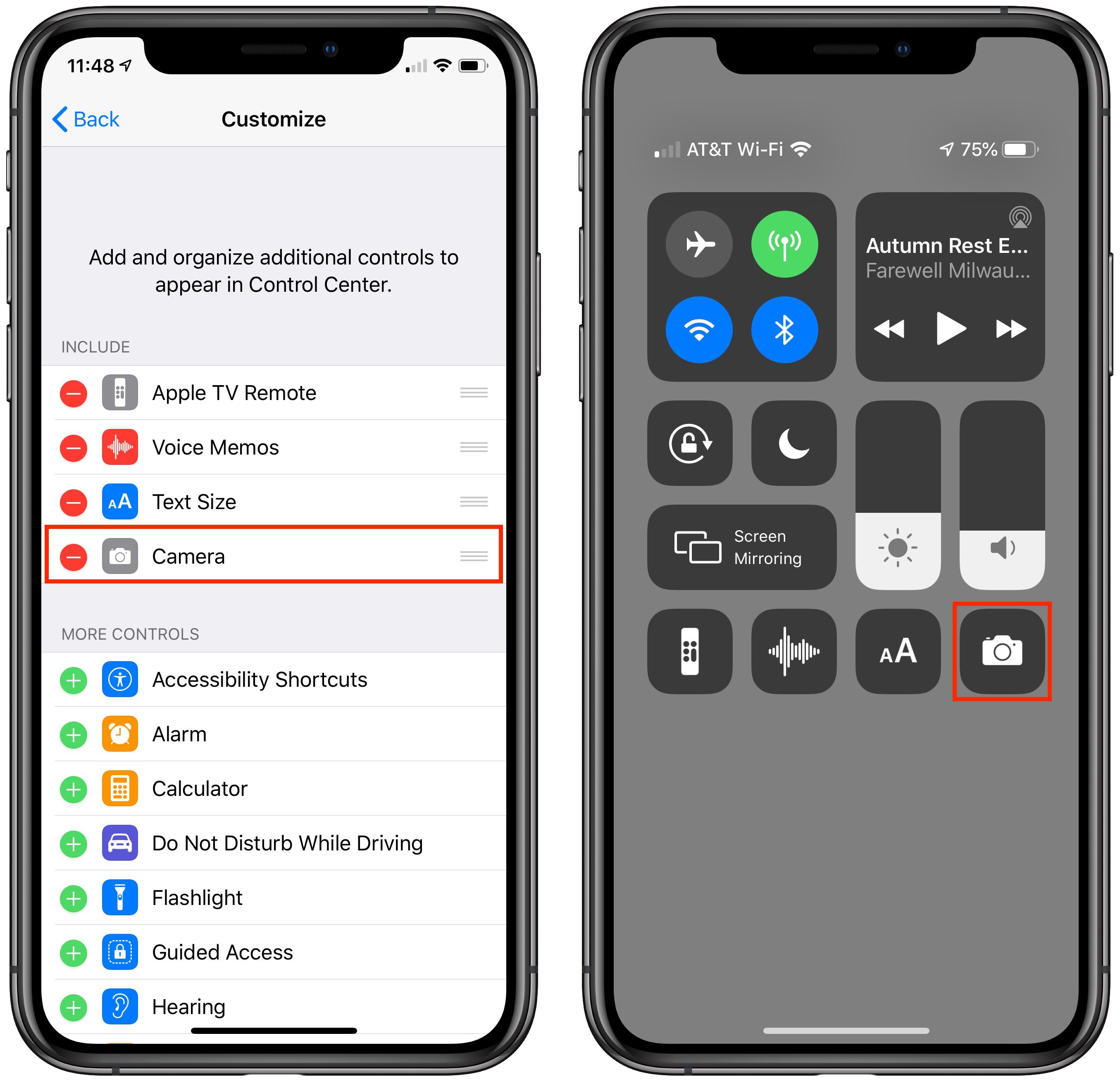
I didn’t think of it at the time, but I could have added the Camera to Control Center (Settings > Control Center > Customize Controls) and accessed it more quickly by swiping down from the upper-right corner of my iPhone X, even when on the Maps-occupied Lock screen. I’d recommend setting that up in advance if you plan to use Apple Maps for walking directions when you also want to be able to take a photo quickly.
Both Apps Show the Direction You’re Pointing
Over the years, my main problem with walking directions, regardless of app, has been figuring out the direction in which to start. Both Apple and Google have improved their apps in this regard. In the past, I’d often find myself walking half a block before it was clear that I had guessed wrong about which direction to go initially. The icon that indicates your position now gives an indication of which way you’re pointing, so you can usually just turn around slowly to figure out which way to go.
The only problem with this is that the icons can be fairly small, and if your close-up vision isn’t great and you’re in bright sunshine, it can be challenging to read the screen well enough to determine direction. Even with the directional icon, I always checked that we were going the right way and several times had to admit that I’d sent us in the wrong direction. Which, as a guy equipped with high-tech mapping gear, was tough.
Large Stations Can Still Be Confusing
When you take the train into Geneva, you arrive at Gare Cornavin, a massive transit hub for both trains and local trams and buses. The problem, and neither app did a good job of helping us, is that there are at least two rather widely separated spots to catch buses or trams. Both apps could tell us which number bus or tram to use, but neither was able to tell us where to find it. Worse, because there were multiple routes that would work and time kept passing, as we tried to figure out what to do, the possibilities—and where to get the recommended bus—kept changing. Since we had arrived late at night and were exhausted, it was all the more stressful.
I have no helpful suggestions about how to resolve this problem. The simple fact is that sometimes, even with these advanced mapping apps, you need some local knowledge to be able to navigate a transit system effectively.
Walking Directions While in a Transit Route Suck
As I noted, setting up a route via transit almost always requires walking to get to the station. The problem is that neither app does a good job of providing those necessary walking directions. Both show you a map with lines that indicates where to go, but neither gives you turn-by-turn directions while you’re walking, forcing you to watch your iPhone and look for turns manually the entire time. I could have sworn they didn’t show the directional icons either, but perhaps that was merely me not being able to see the screen well while walking in bright sun. Regardless, why can’t these apps provide the same interface for walking directions while in a transit route?

I sometimes ended up setting up our transit route in Google Maps before switching out to Apple Maps for separate walking directions to the first station. That was more effective, but particularly in downtown Geneva, Apple and Google often disagreed not just about the best way to get somewhere, but how it could be done at all, forcing us to pick one and stick to it. I suspect either would have worked, but much like when you were a kid and depending on your parents to navigate, it was disconcerting to have them argue.
Bus Routes Aren’t Always as the App Suggests
On our first night in Geneva, after we finally guessed at which bus to take from Gare Cornavin to the Airbnb where we were staying, I was somewhat concerned to see our moving location in Google Maps deviate from the predicted blue line. Luckily, we were still going in the right direction, so we stuck with it, and the bus did eventually rejoin the predicted route and stop where we needed. But because you sometimes have to make quick decisions about whether to stay on a bus or get off because it’s going the wrong way, that deviation made for a fraught few minutes.
Bus Stop Names Don’t Always Match Up
Also trying were the times when the names of bus stops didn’t match with what the mapping apps advertised. The discrepancies weren’t huge, but when you’re already somewhat at sea due to not speaking the language of the area, it can induce uncertainty.
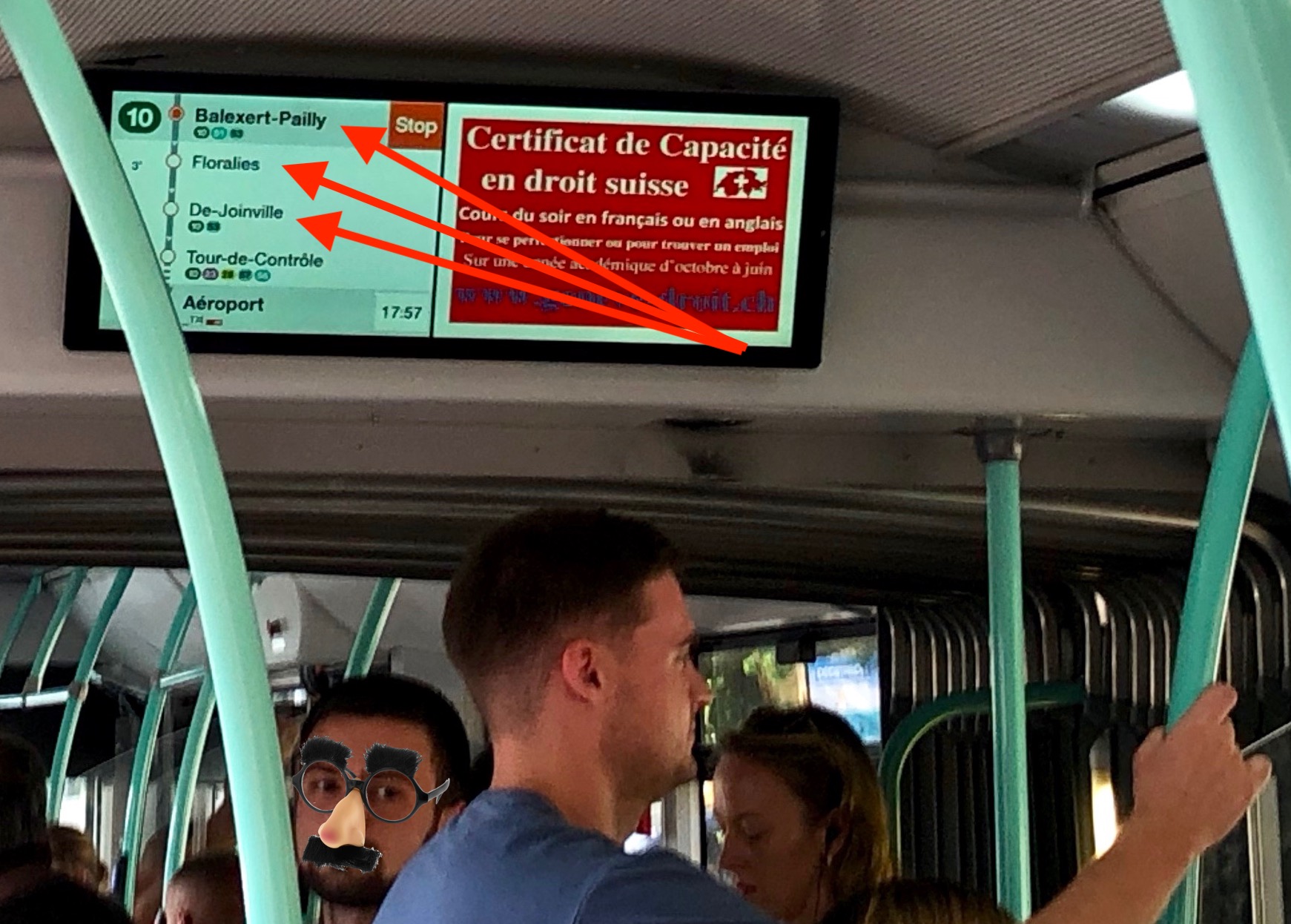
For instance, at one point, both Apple Maps and Google Maps told us to get off at “Cointrin, De-Joinville,” with the previous stops being “Vernier, Balexert-Pailly” and “Vernier, Floralies,” but the screen in the bus that advertised upcoming stops read merely “Balexert-Pailly,” “Floralies,” and “De-Joinville.” It’s easy to see that the first word is being dropped when you have time to reflect, but when you’re hot and tired at the end of a long day and you’re squished into a standing-room-only bus with your backpack, the fact that the names start with different words can be tough to parse. In short, be aware that the mapping apps may use slightly different names.
It’s Hard to Preview New Routes While on Transit
One of the reasons to have at least two mapping apps available at all times is that when you’re on a train in the middle of a transit route, it’s tricky to stop and restart the route, as you might want to do if you want to preview a different possibility or need to switch to a slightly different eventual destination.
That’s because the apps have no way of knowing that you’re already on a train, so they’ll try to direct you to the closest station, which may be behind you or require taking an entirely different transit option if you were on foot at your current location.
I learned quickly that it was best to let Google Maps keep routing us while I switched out to Apple Maps to check out a different route possibility or to ponder what would be involved with the next day’s travel.
Beware the Last Bus of the Day
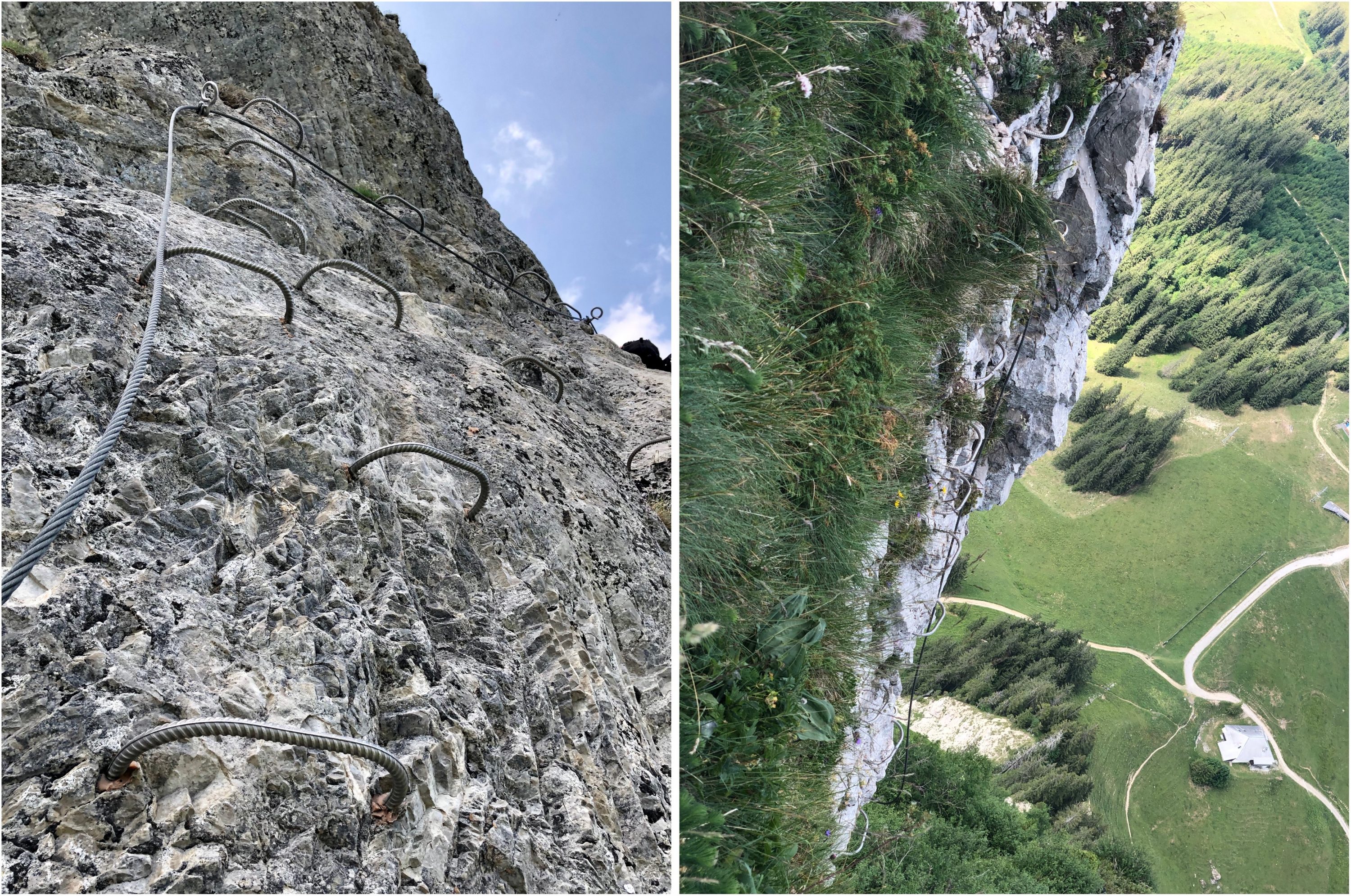
One day we traveled from Grindelwald in the Swiss Alps to Geneva, which involved five trains, two buses, a funicular, a cable car, and a tram, along with bumming a car ride. That was because we went to Moléson for via ferrata and hiking—separately, since Tonya wouldn’t be caught dead clambering up a mountain face that looked like this.
Once we had reconvened at the stunningly scenic restaurant halfway up the mountain (you took the funicular to the restaurant level and then the cable car to the top, or in our case, back down from the top, since I went straight up and Tonya hiked around and up to the peak), I mapped out the rest of the trip to Geneva and was shocked to see that it was predicted to take 18 hours, rather than the 3 hours I had expected.

The problem was that the last bus for the day between Moléson and Gruyere—yes, where they make the cheese—had run for the day at 6:37 PM, and it was just after 7 PM. Both mapping apps therefore thought we should wait until 7 AM the next morning. Luckily, a Swiss family that had also been climbing kindly agreed to give us a ride into Gruyere, saving us a forced 4-kilometer march with full backpacks in an attempt to make the last train out of Gruyere.
Missing this bus took us by surprise because we had become accustomed to being able to go anywhere on the Swiss transit system, at any time. But of course, not all routes run at night. To co-opt a phrase, caveat viator! And read my next after-the-fact observation below.
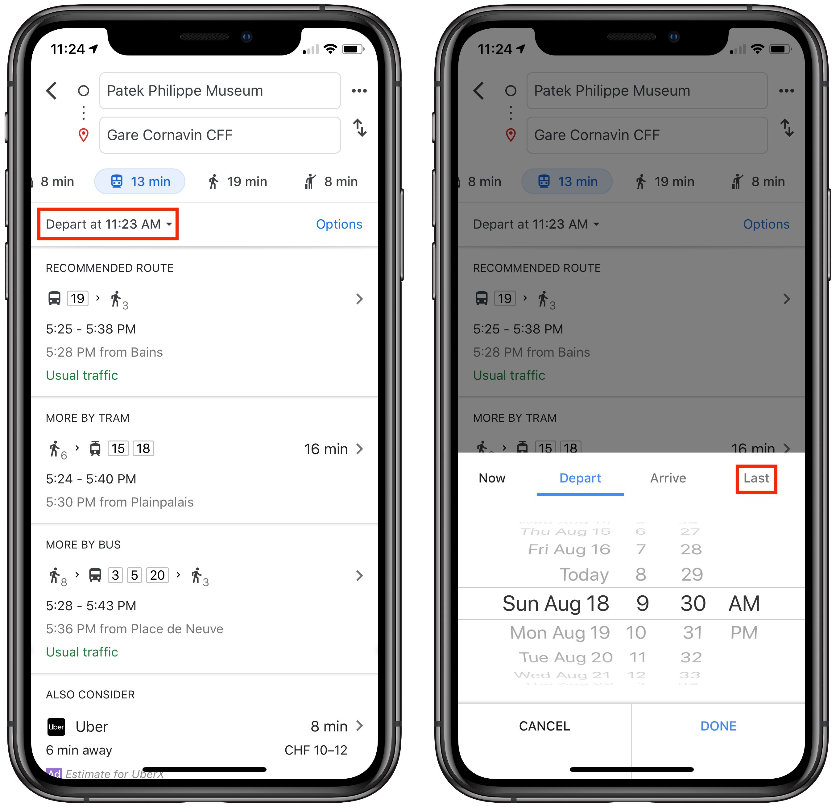
Remember That You Can Set the Route Start Time
Most of the time when you’re using a mapping app, you want to go from your current location to some destination, leaving shortly. You probably know that you can also get directions between two arbitrary places, but you may not have realized that you can also change the leaving time when getting transit directions. That’s important if you need to sync up your day’s activities with transit schedules.
In Apple Maps, once you set up your route, but before you tap Go, tap the Leaving Soon link in the From line, and set the desired date and time.
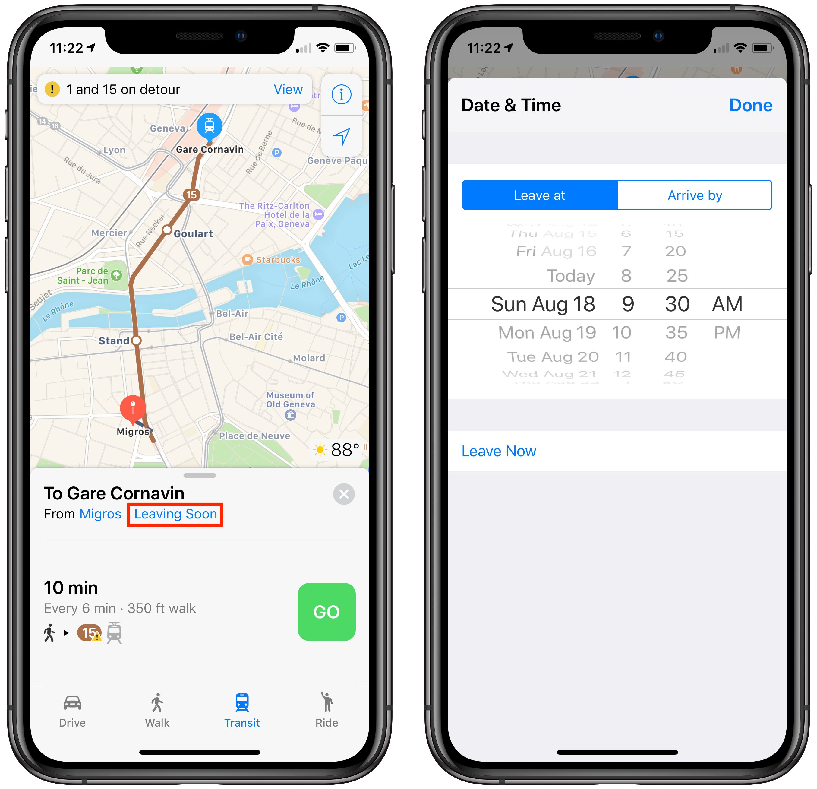
Similarly, In Google Maps, after you set your start and destination spots, but before you pick one of the suggested routes, tap the Depart At menu and set a different date and time. When I did this, I discovered that Google Maps offers a Last option for any given day, which would have been nice to know that day we were on Moléson!
What If There’s No Connectivity?
Neither Apple Maps nor Google Maps ever complained about not being able to download necessary map data while we were in Switzerland. However, our iPhones sometimes showed only the EDGE status icon instead of 3G, 4G, or LTE, and we occasionally noticed the dreaded No Service status as well. Offline maps could have been helpful in such a situation. The other utility of offline maps is that you could put your iPhone in airplane mode to save battery power or to avoid data charges while still being able to navigate. (Your iPhone’s GPS remains active in airplane mode as long as you’re running iOS 8.2 or later.)
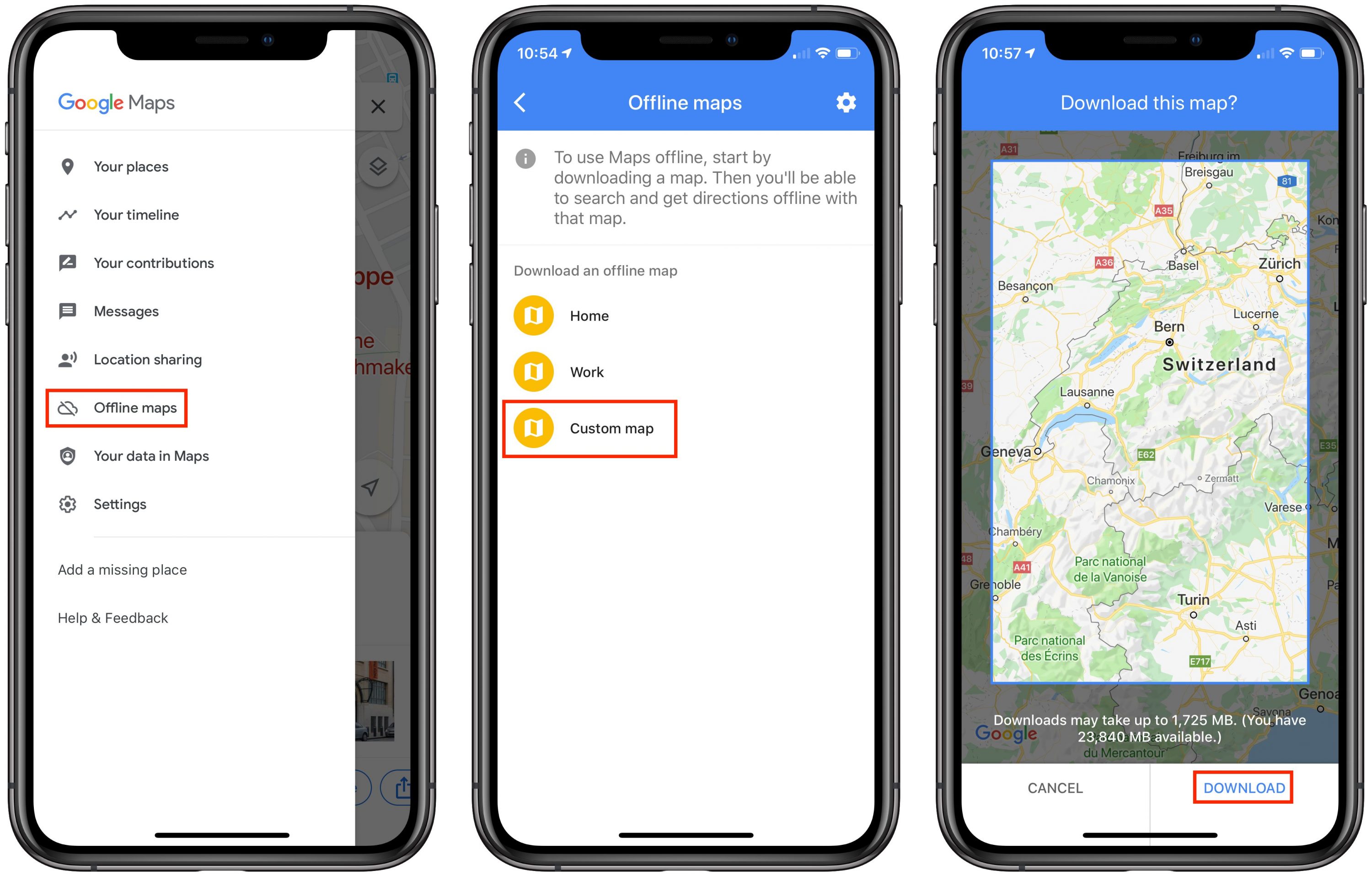
In conversations with friends after we got back, one person pointed out that we could have gotten Google Maps to download offline maps for the areas we were in. Just tap the hamburger menu in the upper-left corner, tap Offline Maps, tap Custom Map, pinch to fit the desired map area into the screen, and tap Download.
Another friend recommended a different app—Maps.me, which offers free, offline maps with turn-by-turn directions. It looks like a competent mapping app on the iPhone, although you must still download maps for the desired location while you do have connectivity. Note that Maps.me supports transit routes in only a limited number of cities. Oddly, that list includes Lausanne, but no other cities in Switzerland.
Apple Maps has no user-controllable provisions for offline usage, but it supposedly caches everything along a route once you tap Go. Plus, if you load an area and zoom in everywhere you might want to go in that area, Apple Maps may cache that data for offline viewing as well. Frankly, I think you’d be insane to gamble on an automatic caching algorithm providing reliable offline navigation. This limitation of Apple Maps is just another reason why you should always have multiple mapping apps available. If you have other recommendations, leave a comment!
A Low-Tech Finale
One final note that’s specific to Switzerland. The most disconcerting thing about the Swiss transit system for us was how we paid for passage. We had each bought a Swiss Travel Pass, which cost about $550 per person, but that meant that we paid only a small, discounted amount for the mountain train that took us up the Eiger to start our 12-mile hike on the Eiger Trail and the funicular/cable car combination up Moléson. Every other trip was free, as was entrance to nearly all museums in the country, so it turned out to be well worth the price.
But the Swiss Travel Pass was literally a piece of paper, and it turned out that you used by writing the month and day into a pair of boxes before you rode each day, since it was good for only 15 days of travel within a 30-day timeframe. We didn’t realize this because that detail was buried in the middle of a page of 6-point text in multiple languages. On the first bus we took, we continued to be confused about how to use our passes and the driver, who didn’t speak English, just grunted at us when we asked. It turns out that the buses are largely an honor system, with no pass checking that we saw.

However, two days later, when we took our first train, the conductor took pity on us for not having written the date on each pass before getting on the train and let us off with what I expect is the standard clueless tourist warning. It seemed like an oddly backward system for a country that prides itself on efficiency, and it left us longing for London’s tap-in, tap-out approach that works with Apple Pay and other NFC-enabled payment platforms. I have to think that the Swiss would love having everything encapsulated within an app that would engender additional appreciation of the precision and punctuality of their transit system.
If you have any other advice on how best to use mapping apps while traveling, please share them in the comments!
My wife & I travel quite a bit throughout Europe, Asia and the US, and like you, we’ve encountered all kinds of issues with batteries as well as walking directions. I love to hike and to that end, I use Gaia GPS to track all of my hikes and pre-plan walking routes. So when we travel, I’ve come to rely upon Gaia GPS as well. I start by downloading a map of the area that we’ll be visiting, so that I have offline access to it. I’ll then add Waypoints of everywhere that I intend to visit, including the airport, my hotel, restaurants, museums, train stations, etc. Gaia will not provide turn-by-turn walking directions, but it will draw a line between your current location and your destination, and I can then choose which streets to walk to get the said destination. I’ve found that this tremendously saves my battery life, while also allowing us to explore a particular city. And when necessary, I’ll consult Apple/Google maps for an address, or bus & train directions.
I also like to use DayOne as a travelogue, as it will automatically keep track of any destination that we visit. I’ll later augment the entry by adding text, pictures, audio or video, as well as keywords so that I can later find the entry much easier. One of the things that I also like about DayOne is that it drops a pin (waypoint) on the map of the various locations that I’ve created entries for, making it fun to see where in the world I’ve been.
Although the article is primarily a comparison of general-purpose mapping applications, it is worth noting that anyone traveling in Switzerland by using the public transit system should have the SBB Mobile app available. It’s very good about giving directions from point A to point B in order to leave A at, or arrive at B by, a given time T. It allows you to scroll the list of possibilities backwards and forwards in time so you can see if minor changes to your schedule make major changes to your travel time. Or to scroll forward to see what the last possible departure for the day is. I particular appreciate that it tells you what platform your train will be leaving from and arriving at, making connections a breeze.
I generally find that both Apple maps and Google are quite poor for walking, as they often miss pedestrian-only routes. In my experience the best source of walking information is using an app like ViewRanger to access Open Street Map. This user-sourced mapping usually has all the pedestrian short cuts & also useful info like playgrounds.
The best apps for combining walking with public transport tend to be apps like Citymapper, which works in many cities around the world & gives you info like which part of a tube train it is best to get on for your particular journey.
I find Here WeGo to be more legible than Apple, Google, or Maps.me, and it works off-line, but I seldom plan a detailed route. For continuing approximations that work on the watch as well, Big Arrow is worth a try.
I have used Pocket Earth on several trips in Europe. It was very good about showing public transportation stops with the bus/train numbers listed. clicking on the stop icon displayed all the route IDs and clicking on the ID would cause the route to highlight. This was really useful in England, Italy, and Portugal. Pocket Earth also shows many (but not all) of the walkways and hiking trails in public parks. Pocket Earth allows you to download map details ahead of time, so you can use it without internet connections. (Having said that, the UI takes some getting used to and seems somewhat awkward compared to Google and Apple Maps.)
We also rely on local web transportation services which can be excellent In some places for real-time stop times and delays.
Or you could, you know, just ask somebody. ;) Since the Swiss use trains and transit a lot they are usually well equipped to tell you where to get on a specific tram or where you’ll find track 33B.
Especially railroad/transit employees in my own experience through the years in Switzerland were most helpful. And their English is usually good in urban areas. Out in the boonies, that’s another issue for sure. Although I have to say, in my experience they were never as annoying as the French about it. ;)
This is excellent advice.
For those without the app, at the very least make use of sbb.ch. Its interface is essentially From: and To:. The best part about it is that although it’s run by the Swiss Federal Railways, it will accept not just train stations or town names, but any address in To:/From: and it will give you directions not just using trains but also including trams, busses, ships, cable cars, private operators, etc. You can use it to get transit directions from literally anywhere to anywhere in Switzerland. It’s a great tool and I could only dream of having something that works that well for transit in the Bay Area (or any other urban area I know in the US).
I recommend Guru Maps for an online/offfline map with directions and recording of route. Really great app and responsive developer. It uses open street map for vector maps, but you can download just the map or the map and directions.
Re rail passes, the reason you have a paper ticket that you have to write is that it is all part of a Europe wide scheme and there is no single ticketing system across the whole of Europe. If you get a Eurail pass or an InterRail pass which covers multiple countries you have the same paper based record keeping that is needed.
Citymapper was already mentioned, but for the cities it covers (for me, London) it does really well at public transport. Including rerouting due to delays. I use it paired with Google Maps—which I find does quite well at walking directions, including pedestrian-only paths through parks, for example. I just can’t bring myself to use Apple Maps, but maybe it’s time for me to get over that hump!
I remember standing on a corner in London in 2008 with a physical map and not knowing exactly where I was. There were no street signs! Soon after we switched to Apple maps on my iPhone. Even on that old phone it worked, slow and spotty, but it worked.
Quick photos… I haven’t tested when Maps is on the lock screen but I just swipe right to left on the lock screen to open the camera. I think ios12 came like this. It works when a notification is displayed on the lock screen.
Switzerland is great for self-planned travel and the scenery is fantastic. Our last trip included the Bern Valley and a trip to the Schilthorn peak Which gives a wonderful panorama of the Alps.
Oh, you were in Switzerland and Lucerne! I really liked to meet you as I live only 20km away from Lucerne and visit the most beautiful city of the world (Lucerne!) often.
It is funny, how you discovered our travel system that is cumbersome for us, too. We have an app from the major railway company that covers most of it, but still not completely. The idea of a tap-in, tap-out system is in the works since more than ten years. But privacy-concerns block the progress…
If you would travel to Europe again, try Komoot App for hiking and biking (komoot.de). You would buy an area (about 30$ for whole Europe) once, then all trails would be to your service. You can download for offline usage too and the battery consumption is by far the lowest I know. I somtimes record (for Photo GPX-Export) my whole day of traveling or hiking without any spare battery. It seems that it does not consume any additional power than the iPhone itself.
This was my first thought when reading @ace’s travails on using the public transport features of Apple/Google Maps. More generally, I don’t really trust their public transport information to be as accurate or useful as the local transport agency, so I would always look for the local public transport app. Though, as others have said, if you’re in a city that CityMapper supports, that is definitely the one to go for – CityMapper will also include walking, bike hire, mixed modes (e.g. bus + underground), etc. It even tells you where to board an underground train to make your exit smoothest, and figures out the interchange stations that require the least walking.
ViewRanger is also excellent to use when hiking, as it provides access to a range of premium mapping, such as the official mapping for many countries. And you can access it through a web browser to do route plotting on the computer and then have it on your phone. I also second the recommendation of Maps.me for generally being out and about. I can’t emphasise enough the value of OpenStreetMap-based apps when you’re exploring a city by foot or bike, they generally have far more detail than Apple/Google Maps, and it’s also easy to download an area and know it’s there ready to use. And Maps.me’s routing includes cycling as well as walking, and takes into account all the additional walking/cycling path data in OSM.
Having lived in Europe for twenty years, apps like Apple Maps make finding one’s way around foreign cities much easier than before. In addition many major cities have their own public transport apps which are also very useful, including features such as real-time maps showing both where you are and the nearest public transport stops with schedules. Frequently these apps have an English option, but even if they do not, the interfaces are pretty straightforward, and using them is part of the fun traveling in a foreign country.
We had rather mediocre luck with finding people who spoke English, particularly in the French-speaking parts of Switzerland. We heard repeatedly that “everyone there speaks English” before we left, but it just wasn’t true for us.
Interesting! That makes sense for the inter-Europe passes, but the Swiss Travel Pass is good only for Switzerland. But without an overarching electronic ticketing scheme, I could see where moving forward would be tough.
No, sorry. When Maps is on the Lock screen, you can’t swipe left to get to the camera, as you can when it’s a normal Lock screen. But Control Center remains available.
Ach, sorry about that! This was the first trip we’ve taken since 1998 that didn’t involve business travel, visiting relatives, or traveling with family, so we kept it quiet.
That’s good to know. We had maps for some of the trails, but it would have been nice to be able to see if there were more alternative hikes.
I’m intrigued to see the multiple recommendations for local transit apps. My limited experience in the US is that Apple and Google have so many more resources than any local transit authority that their apps are vastly better. My assumption has always been that when local transit options are available in Apple Maps and Google Maps, the local transit authority is publishing them in some constantly updated, standardized fashion, so the information would be the same. Apple and Google certainly knew when there were transit problems in Switzerland (for instance, an accident on one route, which actually cleared before we got there), so I assumed they were getting live data from SBB.
I’m afraid if it was in urban areas you just had bad luck. Out in the boonies I’m not surprised at all. Heck, they can’t even understand each other in their native tongue, why would we be able to communicate with them in English? ;) Switzerland in terms of English is definitely not Scandinavia or Holland, but in most cases you’ll be much better off than in Germany or France where especially older people do not (or do not want to) speak English.
I know Citymapper works well in many cities, and it was initially designed as an app for London’s tube system. But here in New York City, which has an almost century long, and very well deserved, bad rap for delays, reroutings, snafus, etc., its transit info is not very reliable. But neither is Apple or Google Maps, though I find them a little better for the NYDOT than Citymapper. Cable TV provide Spectrum’s New York One transit updates are far better, though not perfect, and they are updated every ten minutes.
What surprises me is that years ago, shortly after Google announced they were not going to develop turn by turn directions for its iOS Maps app, and Steve Jobs was literally forced into a buying spree, Apple acquired Hop Stop. It was a really good transit app covering many US cities, and maybe European ones too, and was better in NYC Apple almost immediately dropped the Android version, and Android didn’t as yet have public transport in Google Maps. So I’ve never understood why Apple Maps’ public transport info sucks worse than Hop Stop did years ago.
I’ve been using satellite GPS for over 10 years on my Nokia phones. It takes a few minutes to find the satellite, but I don’t have to bother with cellular networks for maps and guidance. I always knew it was good but didn’t have a comparison until we had to go over a mountain on a dirt road in Crete. I had my iPhone with its maps, and my Nokia N8. The iPhone lost the maps within 5 minutes, and the Nokia satellite GPS directed us on lots of very lumpy dirt roads. We arrived at our destination very slowly after passing through 3 or 4 sheep/goat fences/gates. Didn’t lose the bottom of our rental car either.
Nokia maps has evolved into Here […we go] maps, and it’s excellent with my new Nokia phone. I still use my iPhone for lots of things, but its maps are still not as good. I use Here Maps for walking around in cities/towns. It also has choices for dozens of voices and languages for guidance. There’s also an iPhone version. Does iPhone have satellite GPS without cellular network yet?
Google Street View can help.
I always plan the most stressful parts of our journeys with Google Street View. I always check the timetables for trains and busses to reach the hotel at home. Then I go around the train stations or airport bus terminus and check if I can see any bus stops or metro signs in Google Street View. You can not rely on Street View to have covered all angels, but it helps that I have “been there before” when I arrive. I use the same for the walk from the bus stop to the Hotel.
You have a phone. It should have a translation app. We’ve use this many times in all the places where nobody speaks English. In markets where you want to buy something, I’ve found that the calculator is the best thing to use for haggling…also hand signs and making faces.
Something I’ve always wanted to have on my iPhone is an app that allows me to use third-party maps (on paper) with the built-in GPS. Often you’ll get a trail map from the Park Service that’s really good compared to the stuff you find online (for free). Other cases you’ll be so far off the grid, that paper map is the only thing you can rely on. I’m great with that. I can drop that paper map, I can get it wet and dirty, etc. All things I wouldn’t want to do with a $1000+ device. But the one thing those paper maps don’t have is the GPS dot telling me where I am and which way I’m facing.
So my dream app would allow me to take a picture of that paper map including its scale and it would allow me to select one or several reference points (for example where I am right now) in order to calibrate it to the GPS receiver. From the on, the app would show me the GPS dot you usually see in Maps overlaid on that map image. Now I have a detailed trail map combined with real-time GPS feedback of where I am on that map.
I’m pretty sure Avenza Maps allows you to do this. I used it years ago, and it allows you to import your own map images. But I didn’t use it for long (or recently) enough to fully recommend it as being the solution you’re looking for. Probably worth trying though.
I’ve not had experience with this in the US, so that may be true there. But in my experience elsewhere, it’s not about the quality of the data (as you say, everyone’s using essentially get same data feeds), but the quality of its presentation and context.
Apple & Google Maps are general purpose and have to use a one-size-fits-all model. So they can’t design it around the peculiarities of a local transport network or information that is particularly important. Your experience of last bus times is a good example of that. I’ve just found that local apps tend to present the options more clearly and have more useful ancillary information.
As to the issue of resources, while Apple & Google certainly have more, public transport is a small part of what they’re trying to do, and it can be neglected compared to developers who are focused only on making public transport routing as good as it can be. (In the case of Apple & Google, the public transport part also has to fit into the overall design of an app which seems designed for and focused primarily on driving directions.) So it’s not always an issue of total resources available. I’m not saying that all local apps are better or discounting your experience in the US. Just that I think there are reasons why it can also be the reverse elsewhere.
Thanks, but Avenza wasn’t capable of using any of the maps I had lying around. I tried one from a regional park, and two from the NPS and a CA SP. It wasn’t able to ‘detect’ the coordinates.
“Here we go” app for iPhone and Android does what you need, https://wego.here.com/?x=ep&map=39.6249,-75.8351,10,normal.It does show bus and train stops. And yes, it does understand GPS coordinates…if you can figure out how to type them.
It helps to have local transit apps, too. I’d have quite a time finding my way around DC with Apple or Google maps. The Metro app does everything transport. Google even takes you inside some buildings, like stadiums and theaters, but it doesn’t show you how to drive to Paris, France any more.
Sounds like the fellow who was trying to use GPS to find his way out of the Atacama desert in Chile. His GPS showed him exactly where he was, but couldn’t show him how to get anywhere since there weren’t any roads. I like paper maps, especially the laminated ones.
I often use the Apple map app offline. Bring up a map of the area you want and take a pic.
The photos can be zoomed and moved almost like the map app.
Taking a different tack, you might be interested in giving ViewRanger a try. It has a very good selection of premium maps (including for the US) which are ideal for hiking, etc.
In my experience (iPad Air 2, current iOS at the various times), Google Maps has a minimum download area that is often much larger than the area that interests me. Also, the downloaded map has only a fraction of the detail available when I zoom in while online. I have not seen any options for the offline maps that might affect this. (The only choices I see for saving an offline map are the total area and the orientation.) Have I missed something? Am I doing something wrong? If neither, I suspect that Google Maps offline would not be as useful as one would hope.
IMHO Apple could fix this offline situation in Maps quite easily. Add a toggle in Maps prefs to go into “caching mode” or similar. In that mode, whatever you look at in Maps gets cached to full detail. If there’s no reception or wifi, Maps just draws from that cache. Give the app a blue status bar or something when it’s enabled so people don’t forget. Tap on that blue status bar and you’re shown how much memory is being gobbled up by that cache and presented with the toggle to turn it back off (which would purge that cache). If that cache is left to grow and it uses up a substantial part of people’s memory display a warning with options to turn off caching and/or purge the cache.
It’s a simple mechanism that will stay out of people’s way who aren’t interested, but serves all well who are afraid they might end up outside of data coverage. Just cache the area you’re going to be exploring ahead of time and done.
Obviously, Apple likes to see users as these potential customers who are always online, but especially when it comes to mapping that’s often just not the case. Ask anybody who lives in a more remote area or who enjoys backcountry hiking. Or just sightseeing out of a plane with no wifi.
There would also have to be some way to indicate what area should be prefetched. Caching is by nature retrospective.
ViewRanger (free) allows you to choose a specific area to download (OpenStreetMap-based) maps and then manage them later so you can delete ones you no longer need. Works well if you need this kind of thing.
Google Translate was indeed quite useful, although I found that it was often tricky to bring up quickly enough to be helpful when listening. We never had to resort to it for an actual conversation, since people who didn’t speak English usually just went and got someone else who did (at least a little).
Interesting—I’ve not explored that feature, but it would seem to be relevant if you’re planning on relying on it.
On an all-day road trip this past week, I can give a first hand answer to this: Apple Maps will run out of maps, if you lose connection. However, the line and next turns appear to be cached. But in the meantime, until new maps can be brought in via a live data connection, your display will show you driving through a grid, somewhat Tron-like.
I also tried Google’s offline maps on this same trip, for a different portion where I expected significant loss of cellular reception (the Adirondack Park and the Green Mountains of Vermont). It worked almost flawlessly. I can’t say the bug we saw was related to offline caching, but we saw, on the CarPlay display, the next direction failed to update several times. It appeared to only be a display bug… the map still showed our live location, and my wife was able to tap around on the phone and get my car’s display to correct itself, but it did cause one wrong turn.
Google Maps Tip: if you download a map, there’s a maximum geographic area. For all-day interstate trips, that may not be large enough! All you need to do is download a second map that overlaps just a little. I saw no trouble when my trip started within one, and ended (with many cellular drops) on the second map.
Lastly, I also had Maps.me on the phone with all maps cached. I never used it to navigate because it does not have CarPlay, but I’ve used for trail navigation for years, as it gets its maps from OpenStreetMap, which has a lot of trails. I tested the turn-by-turn route selection (to confirm as an offline backup) and it did choose the same 5hr route from northern NY through the mountains to northeastern Mass. Definitely worth having on your phone.
To find yourself on a map, it’s best to start out with the map and check periodically as you go.
Which way you’re facing is what a compass is for. Not the one in a phone which is easily confused, but a real one. You can get decent ones for cheap, but don’t get a button compass, they’re junk. Get liquid filled, with a movable ring that lets you set the magnetic declination, and look up the declination for each area you go. I grew up in the midwest where it was only about 2 degrees and didn’t matter much and was startled that in the pacific northwest it’s +/- 22 degrees which would get you lost in a hurry if you didn’t correct for it.
One of the things that I loved about Norway was that you could get off the train or bus in any random small town, and for about $1 buy a local orienteering map. They mostly don’t (didn’t?) treat orienteering as purely a race like americans do, but as a way for everyone to get out in the country / forest and have pleasant time with some fun goals, and get extra practice at not getting lost. A woman I met said that when she was 5 years old, her family gave her her first test–to find her way across about a mile of forest alone. She was watched over, but didn’t find that out until it was her little brother’s turn.
I suppose I should look for similar feature in an iPhone app.
I went to Iceland a year ago and in addition to our iPhones and iPads I also took a Garmin 64s handheld GPS unit. There were a good number of times where we’d be without cell reception for a number of hours, and occasionally more than a day, and having a “real” GPS was incredibly helpful. I downloaded maps in advance (and geocaches, but that’s a different post) and had no trouble navigating around the country. It has rechargeable batteries, so no worries about draining my phone either. And the major benefit is that you can find where you are even deep into the mountains. Not incredibly expensive either, and you can download maps for a lot of the world so it’s not required that you buy them from Garmin.
I also used maps.me quite a lot, having pre-downloaded maps of the whole of Iceland beforehand.
I’m totally fine with Apple Maps as I use it all the time, but it was nice to know I didn’t need to depend on it when traveling if I was without either reception or phone battery.
I’m glad both Apple and Google Maps support transit now, but I was disappointed a couple of weeks ago when I was trying to get from New Haven, CT back to NYC JFK Airport on the cheap. Neither offer a “cheaper instead of faster” option so they just said take the Amtrak — starting at $44 and up to $141 if you take the Acela, instead of Metro North starting at $17.75. It was the same thing once in NYC — take the more expensive commuter rail instead of the subway. So I had to use multiple apps and websites and write it all out on paper. I’m sure both Apple and Google know know all the transit routes and fares. Why can’t they put it all together and offer options within transit like they offer car, walk, transit or ride?
This is why you’re better off with CityMapper – it lists multiple options, along with the trip duration and cost.
I just noticed that Apple Maps—despite its new better mapping in California—still doesn’t display hiking trails in parks. Google Maps has no problems displaying them and they appear to be rather accurate if you compare to the park service’s own maps.
We’re not talking serious trekking routes somewhere deep in backcountry. These are regional parks with few-mile long well maintained paths, often fire trails. Many you can make out by eye just looking at the sat images, ironically well visible even in Apple Maps. But switch to mapping mode and there’s zilch. Just faded green surfaces.
A couple of apps I like for travel in Europe are Omio, which has schedules for air, rail, and bus in one app with ticket purchase. It also knows about discount cards that can be purchased by seniors, for example. Free in the app store.
Moovit has excellent transit maps. The bus system in many cities is confusing. Often there is no overall maps of the transit system available online. Moovit will tell you what bus to take, literally walk you to the bus stop, tell you how many stops to your destination and then alerts you that your stop is coming up, at the stop before tells you your stop is next and then tells you to exit the bus at your stop. If there is a walk to your ultimate destination, it guides you there step by step, turn by turn. Free in the App Store.
If you travel frequently or even country hop on your annual vacation, you’ll love TripIt. Trip automatically receives all your confirmations for bookings, made online or made some other way. As long as your are mailed something about your reservation, TripIt gets it and adds it to your trip.
So you bus into the airport, your flight with Gate info and seat number, your train into the city center, you hotel reservation, and your dinner reservation all on ONE screen. If you have actually online tickets or Boarding Passes, TripIt will link to them. The Pro version costs an annual subscription fee and adds text notifications of delays and gate changes and help rebooking after a flight cancellation. But the basic app is free in the app store.
As to Google Maps versus Apple Maps, my vote goes to Google. Now that Apple allows deletion of built in apps, I have deleted Apple maps.
Google has over 1 million volunteer local guides submitting data. Google lends the 360 degree cameras in a backpack so they can gather Street View data from places motorized vehicles and bikes can’t go. Want a Street View of hiking the trail down into the Grand Canyon or walking into the Vietnam Veterans Memorial, Google Maps has got it. Google Maps also has a 3D perspective view with wireframes of the tall buildings and landmarks.
Not to mention Google’s network of photographers who make money filming the interior of businesses who are trying to improve their Google map listings.
Yeah, Google is going to use my data to sell ads most of which I will never see on my MacBook by an effective use of ad blockers. But Apple cannot compete with 1 million human reporters and Google Earth.
Generally I use Apple Maps, the Siri integration works for me and it’s ended up being a kind of default.
I’ve stopped using the GPS apps from Navigon, they’ve discontinued updates and removed them from the App Store but they were, in their time, excellent.
I do a lot of planning for trips and include Google Maps when I require additionality, particularly StreetView as well as trail maps such as Viewranger. I’ve been really impressed with how detailed and informative the various hiking and trail maps are. If I’m going up anywhere specific I hunt for apps or sites that are focussed on that locale, for example, for my hillwalking in Ireland I use mountainviews.ie which has not just maps and trails but also hikers reviews and info, including wayfinding markers and warnings about hazards as well as estimations of difficulty and duration.
We covered TripIt and some similar apps a few years ago:
That’s nothing. I was chairing a meeting of the Gregson Community Association in Lancaster, Lancashire in November 1996. Afterwards, I was exhausted, partly due to the content of the meeting and partly due to poor health. It was a dark night, a bit foggy and everything was grey, including every building in the estate where I lived. I walked back to the house where I was sub-letting and got to Ennerdale Close, I think, and I’m sure I stood outside my door but could not be sure because the street sign was missing, everything was dark and grey. My head was swirling, my eyes might have been swivelling. I walked downtown to the bus station, hopped in to a taxi, said “Ennerdale Close, please” and 10 minutes later I was home.
Back in 2011-2012, just days after I got my beautiful new iPhone 4S featuring the just out of beta Siri, I had a job interview in an unfamiliar neighborhood in the wilds of Brooklyn. There was an especially nasty ice/sleet/snowstorm that day, so my husband drove me there but couldn’t wait to pick me up afterwards. So I confidently asked Siri for “directions to the nearest subway station,” and in my fancy nice shoes slipped and slid for many, many blocks that seemed like slogging miles in the Antarctic. Siri sent me to a Subway sandwich place that was in the opposite direction of the nearest subway stop.