Comparing Apple’s Old and New Map Data
In September 2018, Apple announced that it was working to enhance the data underlying its Maps app, promising completion by the end of 2019. In the fifth update so far, Apple released new map data for the Northeast United States. Justin O’Beirne, who has done detailed examinations of Apple Maps and Google Maps in the past (see “Cartographic Comparison of Apple Maps and Google Maps,” 22 June 2016), is back with a fascinating look at how much more detailed the new data is than the old. The additional data will also presumably result in better navigation directions, although that’s harder to quantify. Regardless, it’s well worth scrolling through O’Beirne’s piece to see all the interactive Old Map/New Map screenshots.
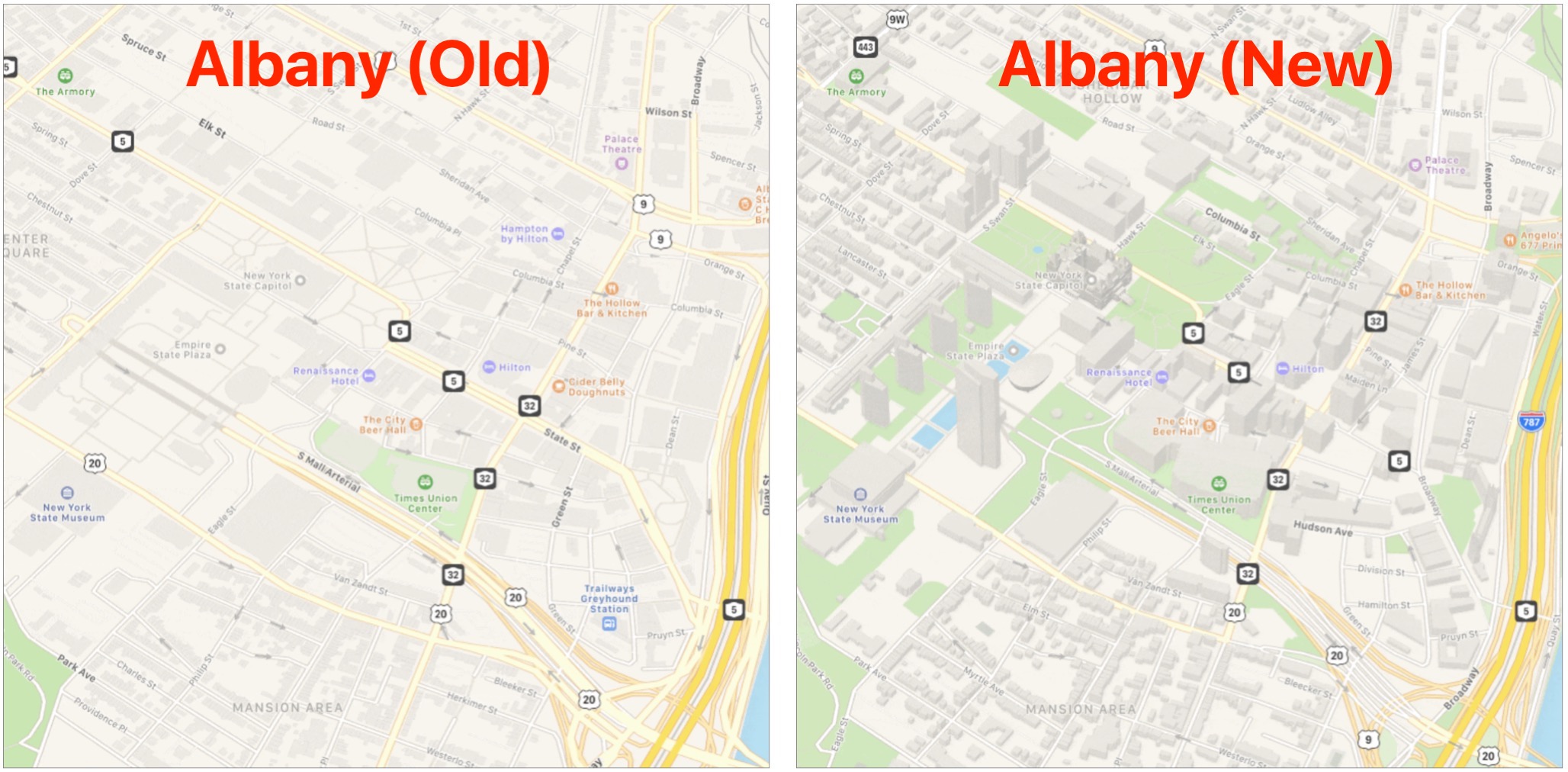
The old & new comparisons are useful. Evidently Apple is doing its bit in greening the planet!
So the Southeast hasn’t even been touched by Apple. Florida is the 3rd largest State in the country, soon to be #2, displacing New York, and maps still isn’t updated for the Sunshine State.
No thanks, Apple. I’m definitely a fan-boy about most things Apple, but for maps, I’ll keep using Google.
I saw their map cars driving around my neighborhood a few months ago. But they still show a weird roundabout route from my house to my station. Google maps shows the correct, direct route.
Here in Wales I can see ONLY regression in Maps. I enter a route but don’t commence it as I KNOW the main highway and don’t want the annoying voice (Miss-pronunciation and clipped road numbers, reported AD NAUSEUM!) Maps just drops the route!! When I start again it doesn’t recognise the post code or tighter address info that it’s used BEFORE!!! Pathetic!!!
Apple has now expanded Maps with data on the Midwest and West, and Justin O’Beirne has another post showing the changes.
https://www.justinobeirne.com/new-apple-maps-midwest-west
FWIW, I saw an Apple map car driving through a shopping center in Newport Beach, California on Nov. 16. Perhaps they are updating images.
Here’s the last of Apple’s updates for the United States, with commentary from Justin O’Beirne. On to Europe!
https://www.justinobeirne.com/new-apple-maps-continental-united-states
No “street view” here.
You’d think Raleigh would make the cut.

#3 in the world.

Don’t feel bad about Street View. I live in New York City in a large, block long apartment building and ever since the map revision it locates me on the south side of the building when I am sitting on the north side. This never happened in every other iteration of Maps.
I hope I don’t sound like I’m whining too much, but Apple, Google and CityMapper do not update NYC public transportation issues often enough for them to be considered reliable. If I’m correct in assuming that this is the case in other major metropolitan areas, the money Apple spent on the 3D street view would have been better invested on improving transit info.
I was in NYC for a long weekend as a walking visit last Labor Day weekend. I hadn’t been in the city for 30 years. I had forgotten just how much of the signage and such for transist in that city is more of a reminder for those in the know
than an instruction of use noobs. Did a LOT Of walking the wrong way 2 blocks underground to the wrong side of the track going the wrong way.
Still it was a nice weekend. Great weather and hotels. But my wife wasn impressed in the wrong way that we did about 30 miles of walking in 3 days.
Paris was something else also. I swear they don’t want strangers to find the subway entrances. I finally figured out the way to find them was to find the metal framed kiosks that were the ticket booths over 100 years ago but later converted
to sell magazine, food, whatever. If there was one of those the entrance must be near. Sort of. Mostly. Many times Google Maps would say we were at an entrance and it would take 10 minutes of exploring to figure out it was the unmark stairs leading under
the fancy entrance to a major building.
In general I’m a Google Maps kind of guy. But mainly because Apple Maps grinds my gears way more often than Google Maps has in the past.
Just another comment. Places like Manhatten are tough for GPS systems without an inertia systems or beacons nearby to help. The tall buildings mess with the incredibly weak GPS radio signals. I’ve noticed this in any major concentration
of tall buildings. I get much better accuracy when in the middle of nowhere (PCA ½ way up to Oregon with no cell service for 20 minutes) when using cached maps than in midtown Manhatten.
Something I’ve wondered about with Apple, and especially Google, is why they don’t build something like Waze’s user reporting features into their Map apps for public transportation. A cable news station here in NYC has very good traffic and transit reports every ten minutes, and they publicize that a lot of it is dependent on user feedback. However, they don’t update their app often enough to make it effective for people on the go.
Interestingly, Google owns Waze. As far as I know, they share map data and the Waze traffic data is used by Google Maps to indicate congestion (the yellow and red lines on maps) and to create travel time estimates.
You are absolutely correct, however, that the Google Maps app doesn’t include a way to explicitly report conditions. I assume they use location data to estimate travelers’ speeds and (by comparing against historic speeds for your location) use that to make intelligent guesses about congestion, but that’s all speculation on my part.
I assume this because I’ve noticed that they frequently flag sections of road near traffic lights as congested even when the road is pretty clear. I’m assuming that their software sees everybody slowing and stopping there in order to come to the conclusion that it is congested.
Apple be doing something interesting with Maps in Miami for the Super Bowl. I suspect this could mean they will be rolling out in Florida soon:
“Before the Super Bowl, Miami is also getting the real-time transit feature, which shows locations of buses and trains alongside arrival and departure times. Apple said it will add real-time transit to more cities over time.”
I hope this indicates they might be improving public transit information across the country.
An interesting new development that could mean more changes to mapping apps in the US:
"Currently, GPS Applications—Google Maps, Apple Maps & Waze—Do Not Contain Data Warning Commercial Drivers Of Roadway Restrictions Such As Maximum Vehicle Height; In The Last Decade, The King Street Bridge In Westchester County Has Been Struck ~150 Times
With No End In Sight To Major Uptick In Bridge Strikes, Schumer Urges Smartphone-Based GPS Application Developers To Implement A Warning System For Commercial Vehicle Drivers To Alert Them Of Restrictions & Hazards. Schumer To GPS Industry: One More Bridge Strike Is One Too Many"
I have a minor gripe - they insist I enter my work address - but I am retired. So the real estate in the list of favorites is taken up by a thing called work. We have 2 kids and their addresses would fit perfectly so I can just tap on one of them in the two spaces provided; or someone else might use that space for say a doctor’s address, their vet’s address, their favorite Apple store, who knows what. Yes, it is minor but it is an irritation. And i agree with the David Ross’ comment about attention to Raleigh - I would add, with all the tech business located here ,they might have wanted to impress their cohorts with “street view” - nah - lol. He makes a good point. Thank you David!
See the story on how someone is creating virtual backups in Google Maps by putting 95 smartphones in a wagon and dragging to to intersections. No traffic but Google Maps believes there is congestion.
In the past truckers used special GPS units that provided information of interest to them, such as maximum height. I don’t know if the makers of these units are interested in making software equivalents or the amount of effort it takes to maintain these databases.
Have truckers switched to smartphones or do they continue to use commercial grade GPS units.
I live a few blocks away from an underpass that was built in the 1930s that feeds into an entrance to a highway. Big RVs and small charter busses and delivery trucks get stuck in it a lot more than in recent years.
The thoroughfares that Sen. Schumer mentioned are actually “Parkways” not Highways, and were built in the NY metro area after WWII when the automotive market began taking off like wildfire and suburbs were growing exponentially. They were designed for commuters, daytrippers, visitors and built with lower bridges specifically designed to exclude commercial vehicles. One of the problems that has particularly hit NY, CT and NJ in recent years is that online retail has changed shipping, specifically when Amazon and other electronic retailers began allowing FedEx and UPS to subcontract the last leg of delivery to independents. They tend to be just about anybody or small company with at least one large vehicle. These drivers tend to use Waze, Google or Apple Maps.
I just saw that article. Hacking Google, a red handcart for red roads
I guess that proves my theory about how Google Maps is getting its traffic data
I checked Garmin’s web site and they continue to make trucking GPS units that include road restrictions.
Schumer’s press-release talked about individuals renting trucks (e.g. students moving their stuff to Boston at the start of a school year) and using the same GPS they use for their cars. He didn’t really focus much on actual commercial drivers, even though that’s what they headline said.
The occasional truck driver is a bigger issue. If someone is going to use their personal phone for a very infrequent rental, how likely is it that they will configure the phone for truck mode, entering the vehicle’s dimensions? And if the app nags drivers every time they begin a trip, the overwhelming majority of users, who are in passenger cars, will get really upset.