21 New Features Coming to Apple Services in 2023
In a Newsroom post, Apple writes:
Apple’s world-class services are an integral part of many millions of users’ everyday lives, from helping them discover new artists on Apple Music, to catching up on current events with Apple News and Apple Podcasts, and navigating and exploring the world with Apple Maps. Later this year, users worldwide will be able to discover, enjoy, and accomplish even more on their favorite Apple devices with new features and enhancements arriving with iOS 17, iPadOS 17, macOS Sonoma, watchOS 10, and tvOS 17.
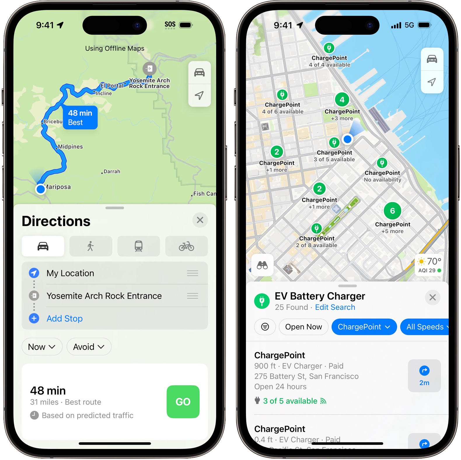
Read Apple’s post for the complete list, but the new features I’m most looking forward to are offline maps in Maps, real-time electric vehicle charging availability (as we start researching an all-electric replacement for our Subaru Outback), and presenting ID in a privacy-protecting manner using Wallet. Also intriguing is this:
Share and request locations using Find My with Messages and Maps. Users will be able to share their location — and request someone else’s location — through Find My directly in Messages with the new “Location” option in the Send Menu. From here, users can also easily create a route to someone’s location in Maps.
Will this work in Emergency SOS via satellite? As I wrote in “Testing Emergency SOS and Find My via Satellite” (21 November 2022):
A better solution [to the problem of people not knowing to check for your sent-via-satellite location] is obvious…. Just use Messages to send your location via satellite! In Messages, tap the avatar for someone with whom you’re having a conversation, and then tap Send My Current Location to share a map with a pin. Sadly, when I attempted to do this in a satellite-only area, it failed.
Finally, not that I ever hold out hope that Apple will listen to my ideas, but I still think Apple Music would benefit from an optional DJ mode that would identify the next artist and song when shuffling (see “Four Ways Apple Could Improve Apple Music,” 11 March 2019).
Which of Apple’s forthcoming service features do you find most compelling?
In addition to offline maps and AirTag sharing, this is one of my favorites:
Maps was in dire need of improvement to trails, especially in National and State Parks.
Meh. Maybe the offline maps but since I prefer Google Maps over Apple Maps…
Offline maps for remote areas was the last thing I needed Google maps for. I much prefer Apple Maps’s “turn at the next light” to Google’s “turn in x feet”.
It’s all how one’s brain operates. I’m much more verbal than visual.
@Simon Agreed, overdue, I also use and you probably know All Trails, a good app - https://www.alltrails.com/
Google Maps has more utility still, I like their nearby secondary search more. But I hate how it looks compared to Apple Maps, which is much easier to glance at and know what to do while driving. For day to day and local I use the Apple version.
That all said, for long distance I use Waze, the alerts to hazards and cameras are useful. It’s also the only one which will audibly alert me if I exceed a speed limit, easily done on our rural roads. It’s not 100% accurate on speeds but close enough to temper my driving.
I’ve started using Apple Maps more because of this too. Internalizing distance in an unknown area isn’t nearly as easy as going by landmarks.
Apple Maps has been catching up with Google with alerts about speed warnings. It now works well with alerts when entering school zones, at least in the busy area where I live.